Tuesday, July 22, 2014

South America - Geography

South America, the planet's 4th largest continent, includes (12) independent countries and (3) major territories; the Falkland Islands, Galapagos Islands and French Guiana.

The continent contains the world's highest waterfall, Angel Falls in Venezuela; the largest river (by volume), the Amazon River; the longest mountain range, the Andes, and the driest place on earth, the Atacama Desert in Chile.

In addition, it includes the largest rainforest, the Amazon Rainforest; the highest capital city, La Paz, Bolivia; the highest commercially navigable lake in the world, Lake Titicaca; and, excluding research stations in Antarctica, the world's southernmost permanently inhabited community, Puerto Toro, Chile. 


south america landforms

Amazon Basin:
The Amazon Basin (Amazonia) is covered by the largest tropical rain forest in the world, and running through its heart is the Amazon River and its more than 1,000 tributaries, seven of them more than 1,000 miles in length. Measurable rain falls on an average of 200 days a year here, and total rainfall often approaches 100 inches per year.

The basin drains over 2,700,000 sq. miles, and covers about one-third of South America. Rising high in the Andes, the river's network irrigates almost half of the continent, and in terms of volume of water discharged into an ocean... it's the largest in the world.

Andes Mountains:
This toothy-edged mountain system, some 4,500 miles (7,240 km) in length, extends from the southern tip of South America all the way to Panama.

It's the source of most major rivers on the continent, and its many ranges include dozens of peaks that reach over 20,000 ft; the highest point being Aconcagua in Argentina, at 22,384 ft. (6,960m). It's also home to some of the planet's largest volcanoes, and in the far south along the coast of Chile, large glaciers and ice sheets are commonplace.

Atacama Desert:
Sparsely populated and positioned high into the Andes of Chile, this somewhat small desert (or plateau) is a cold place, and one of the few deserts on Earth that doesn't receive any rain. It's approximately 100 miles wide and 625 miles long. The landscape is totally barren and covered with small borax lakes, lava flow remnants and saline deposits.


south america 

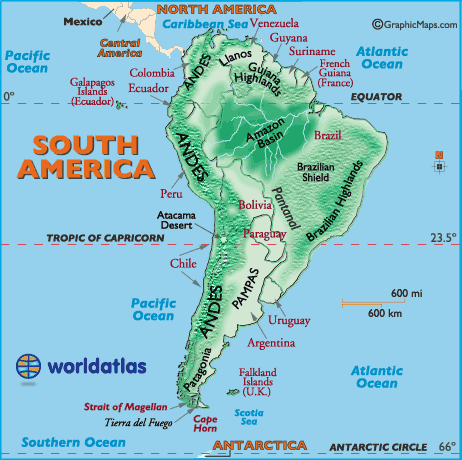
Brazilian Highlands:

This magnificent landscape of southeastern Brazil is 800 miles in length and contains varied mountain ranges, namely the Serra de Mantiquiera, Serra do Paranapiataba, Serra Geral, and Serra do Mar. The estimated highest point is 7,368 ft (2,245m).

Brazilian Shield:
The shield is a geologic formation lying south of the Amazon. Hundreds of rivers and streams flow through this area on their way to the Amazon These rivers contain a large number of migratory fish species.

Cape Horn:
The southernmost tip of South America, remains a maritime legend to this day, as sailing around this remote point and through its violent stretch of chaotic water is one of the most challenging nautical routes on the planet.

Guina Highlands:
Over 1,000 miles in length, the Highlands stretch from southern Venezuela to the northern border of Brazil. It's a vast plateau, one marked by deep gorges, tropical rain forests, numerous rivers and waterfalls. It's famed for the highest waterfall in the world (Angel Falls) at 3,212 ft (979m) high. The highest point is Mt. Roraima on the borders of Brazil, Guyana and Venezuela at 9,219 ft (2,810m).

Llanos:
This large and very fertile plain, located in eastern and central Colombia, and central and southern Venezuela, is drained by the Orinoco River and its many tributaries. It's approximately 225,000 sq. miles (582,000 sq. km) in size.

Pampas:
Famed for its many cattle ranches, this large plain in the southern part of the continent (in central Argentina) extends for almost 1,000 miles (1,600 km), and covers 294,000 sq. miles (761,460 sq km).

Pantanal:
The Pantanal is the world's largest wetland of any kind. It lies mostly within southwestern Brazil, and covers an area estimated at between 140,000 square kilometers (54,000 sq mi) and 195,000 square kilometers (75,000 sq mi). It contains an astonishing collection of aquatic plants and a wide variety of of animal species.

Patagonia:
Located between the Andes and the Atlantic Ocean, and about 1,000 miles in length, Patagonia stretches south from the Rio Negro River to Tierra del Fuego and the Strait of Magellan. It's mostly rugged, barren land, famed for its beauty and striking mountain scenery.

Tierra Del Fuego:
Located at the southern tip of South America, the Tierra Del Fuego archipelago includes one large island (18,571 sq miles, 48,100 sq km) in size, and a series of smaller ones. It was reportedly named by the Portuguese adventurer, Ferdinand Magellan, the first explorer to circumnavigate the globe. His chosen route through the Magellan Strait proved to be the fastest and safest connection between the Atlantic and Pacific Oceans for sea-going commerce and exploration. 

Europe - Geography


EUROPE MAP:

Europe is the planet's 6th largest continent AND includes 47 countries and assorted dependencies, islands and territories. Europe's recognized surface area covers about 9,938,000 sq km (3,837,083 sq mi) or 2% of the Earth's surface, and about 6.8% of its land area.

In exacting geographic definitions, Europe is really not a continent, but part of the peninsula of Eurasia which includes all of Europe and Asia. However, it's still widely referred to as an individual continent.

The European continent, bordered by numerous bodies of water, is separated from Asia by Russia's Ural Mountains and by the Caspian and Black Seas. It is separated from Africa by the Mediterranean Sea.


EUROPE GEOGRAPHY FACTS:

For additional geography details please use the yellow navigation bar at the top of this page. Note that some stats shown below are found in European Russia, even though that landmass is geographically considered a part of Russia, an Asian country.
  • Ukraine is Europe's largest country
  • The Vatican is Europe's smallest country
  • Germany is Europe's largest country by population
  • The Vatican is Europe's smallest country by population
  • Europe's highest point is Mt. Elbrus in Russia
  • Europe's lowest point is the Caspian Sea bordering Russia

  • (If European Russian is excluded, the highest and lowest stats shown below apply to continental western Europe)
  • Europe's highest point is Mt. Blanc in France and Italy
  • Europe's lowest point is Lemmefjord in Denmark

EUROPE GEOGRAPHY NOTES:

european russia
The Russian landmass west of the Ural Mountains is commonly referred to as European Russia in most educational atlases, and by the vast majority of geography experts. It is not a separate country, but rather called that because of its longterm political, cultural and geographical blending with the bordering European countries. For reference purposes it is shown above, however, the entire country (as a whole) is still considered part of the continent of Asia.

European Russia comprising roughly 3,960,000 sq. km (1,528,560 sq. miles) and spans across approximately 40% of Europe. Its Eastern border is defined by the Ural Mountains and in the South it is defined by the border with Kazakhstan. Note that nearly 77% of the entire Russian population (about 110,000,000 people out of an approximate total Russian population of 141,000,000) lives in European Russia.

landforms

Alps:

Located in south-central Europe, they extend for almost 700 miles from the coastline of southern France (near Monaco) into Switzerland, northern Italy and Austria, then southeast through Slovenia, Croatia, Bosnia and Herzegovina as the (Dinaric Alps). They end in Albania on the rugged coastline of the Adriatic Sea.

Known for stunning scenery, glaciers, lakes and valleys and the best skiing conditions on the planet, they're the source of many rivers and tributaries including the Danube, Po, Rhine and Rhone.

The highest point is Mont Blanc at 15,771 ft. (4,807 m)

Apennines:

The source of almost all rivers in Italy including the Arno, Tiber, and Volturno, the Apennines Mountains (Ital. Appennino) 830 miles (1,350 km) in length, form the backbone of the country, and run the entire length of the Italian Peninsula, ending on the island of Sicily.

The highest point is Mt. Corno at 9,560 ft. (2,914 m).

Atlantic Highlands:

Formed million of years ago during the Caledonian mountain-building periods as western lands were (forced) or pushed against the Scandinavian Shield. Significant mountain ranges here include the Kjolen in Norway and Sweden, and the Pennines that stretch through the central United Kingdom.

europe


Balkan Mountains

These mountains extend from Yugoslavia across Bulgaria. Additional ranges run through Albania, Greece and Macedonia.

Its most famous mountain is Mt. Olympus, the highest and most awe-inspiring peak in all of Greece. In ancient times it was the mythical home of Zeus, and was declared the first national park in Greece in 1939. It stands at 9,568 ft. (2,918 m).

Carpathian Mountains

This mountain system located in eastern Europe is the source of the Dniester, Tisza and Vistula Rivers. They form the natural border between Slovakia and southern Poland, and then extend southward through Ukraine and into Romania.

There are major subdivisions, and the highest point is Mt. Gerlachovkain in northern Slovakia, standing at 8,711 ft. (2,655 m).


Caucasus Mountains

Stretching from the Black Sea to the Caspian Sea, these volcanic mountains have many peaks above 15,000 ft. (4,572 m).

The highest point (and the highest point in Europe) is located here; Mt. Elbrus at 18,506 ft. (5,642 m).

Great Hungarian Plain
Located in southeastern Europe, and surrounded by mountains, the land features several small forests and large patches of grassland. It averages only 100 meters above sea level and often suffers from dry conditions, thus relying on winter snow run-off from the Alps and Carpathian Mountains.

Kjolen Mountains
This jagged mountain system runs along the border of eastern Norway and western Sweden. The highest point is Mt. Kebnekaise, standing at 6,965 ft. (2,123 m).

Massif Central
This mountainous plateau of southeastern France is the source of the Allier, Creuse and Loire. It's about 32,189 sq. miles (85, 001 sq. km) in size, and the highest point is Puy de Sancy at 6,186 ft. (1,885 m).

Mesata
The central plateau, or Mesata, covers nearly half of the entire country of Spain. This high plateau averages about 2,300 ft. (700 m) in the north, and 2,000 ft. (600 m) in the south.

It's surrounded by a series of mountain ranges including the Cantabrian, Sierra De Gata and Sierra Guadarrama in the north and central, and the Sierra Morena and Sierra Nevada in the south.

These mountains separate the Meseta from the Costa Verde, the Ebro valley, the Mediterranean and the valleys of Andalucia.  

North European Plain
The fertile North European Plain slopes to the north-northeast from the Alps, extending to the Baltic Sea, and on into Denmark and southern Finland, Norway and Sweden. It continues east for almost 2,500 miles (4000 km), on into the Russian Federation.

The land is largely flat with smaller areas of hills, including the Central Russian Uplands. Farming is prevalent and agricultural communities dot the landscape.

Pyrenees

These mountains form the natural border between France and Spain and extend for about 270 miles from the Bay of Biscay to the Mediterranean Sea. The highest point is Pico de Aneto at 11,168 ft. (3,404 m)

Scandinavian Shield
An ancient area of rocky earth peppered with granite rock that was literally ground down by receding glacial ice sheets. It's a rolling area of land covered with thousands of lakes (mostly small), linked by rivers.

Ural Mountains
The Urals are 1,640 miles (2,640 km) in length and extend from the northern-edge of the Russian Federation down through Kazakhstan. They form a natural border between Asia and Europe.

The highest point is Mt. Narodnaya at 6,214 ft. (1,894 m). 


rivers

Hundreds of rivers and their tributaries cross the European continent. Here we highlight those over 600 miles in length, and a few others of note.

DANUBE

Beginning in the Black Forest region of Germany, it flows across central Europe and the countries of Austria, Hungary, Croatia and Yugoslavia. It then forms the border between Romania and Bulgaria, turning north across Romania to eventually end in the Black Sea.

It's (1,771 miles) (2,850 km) in length, and one of the most significant commercial waterways on the continent.

DNIEPER

Rising in the southwestern part of the Russian Federation, it flows generally south through Belarus, then southeast through Ukraine, ending in the Black Sea. Overall it's (1,420 miles) (2,285 km) in length.

DON

Beginning it the southwestern Russian Federation, to the south of Moscow, it flows southeasterly towards the Volga, then turns abruptly west, ending in the Sea of Azov. Overall it's (1,224 miles) (1,969 km) in length.

ELBE

Rising in the Czech Republic, the Elbe River then flows north through Germany, ending in the North Sea near Cuxhaven. It's (724 miles) (1,165 km) in length. 

European Rivers, Map of Europe Rivers, Map of Rivers in Europe, Major Rivers in Europe

LOIRE

Recognized as the longest river in France, the navigable Loire begins in the foothills of the Massif Central, then flows north and west across the heartland of France, finally ending in the Bay of Biscay. It's (634 miles) (1,020 km) in length.

ODER

Rising in the rugged mountains of the eastern Czech Republic, it flows west and north through south-central Poland, eventually emptying into the Baltic Sea. It's (567 miles) (912 km) in length.

PO

Italy's longest river begins in the upper reaches of the Alps, flowing west to east across northern Italy, ending in the Adriatic Sea. It's (405 miles) (652 km) in length.

RHINE

Forming in the mountains of southeastern Switzerland, this legendary river flows west, forming Switzerland's northeastern border with Germany, then runs directly north through western Germany forming part of that country's border with France, then finally dissecting the Netherlands and ending in the North Sea.

Numerous tributaries and branches run in all directions, and in overall length is (820 miles) (1,319 km). 

RHONE

Begin high in the Swiss Alps, this fast moving river flows into the eastern end of Lake Geneva, then south through south-eastern France, emptying into the Mediterranean Sea.

Small branches run in all directions, and in overall length, it's (300 miles) (485 km).

SHANNON

Rising in northwestern Ireland, it flows south through a series of lakes, then turns west to eventually empty into the Atlantic Ocean. It's 230 miles (370 km) in length.

TAGUS

The Tagus River rises in the central highlands of Spain, flowing southwest across Portugal, then south to Lisbon and the Atlantic Ocean. It's 626 miles (1,007 km) in length.

Volga

The Volga is the largest river in European Russia in terms of length, discharge, and watershed. It flows through central Russia, and is widely viewed as the national river of Russia. It's 3,692 km (2,294 mi) long


North America - Geography

landforms

Alaska Range:
Mountains of south-central Alaska that extend from the Alaska Peninsula to the border of the Yukon Territory, Canada. The highest point in North America, Mt. McKinley, 20,320 ft. (6,194 m) is located here.

Appalachian Mountains:
The Appalachians, about 1,500 miles in length, extend from central Alabama in the U.S. up through the New England states and the Canadian provinces of New Brunswick, Newfoundland and Quebec.

Significant Appalachian ranges include:

  • The Cumberland Mts. in Tennessee
  • The Blue Ridge Mts. in Virginia
  • The Alleghenies in Pennsylvania
  • The Catskills Mts. in New York
  • The Green Mts. in Vermont
  • The White Mts. of New Hampshire
The highest point is Mt. Mitchell in North Carolina at 6,684 ft (2,037 m)

Brooks Range:
Mountains of northern Alaska. Highest point: Mt. Isto, 9,060 ft. (2,760 m)

Canadian Shield:
This plateau region of eastern and northern Canada and the Great Lakes area of North America mainly includes rough and rocky surfaces, and large areas of coniferous (evergreen) forests. In addition, the northern regions along the Arctic Circle are comprised of rocky frozen tundra. The highest elevation is estimated at 1,640 ft (500 meters).

Cascades:
A mountain range stretching from northeastern California across Oregon and Washington. Major peaks included Mt. Hood, Mt. Ranier, and Mt. St. Helens.

Coast Range:
Mountains running along the Pacific Ocean coastlines of California, Oregon, Washington. They also extend along the western border of British Columbia, Canada, and the southern edge of Alaska, all the way to Kenai Peninsula and Kodiak Island.

Coastal Plain:
This area of the southern and southeastern U.S extends to the continental shelf and is generally characterized by level (flat) land with assorted mixed forests. The coastal areas include bayous, deltas, marshes, mud flats and swamps.

Continental Divide:
In North America the Western Continental Divide is an imaginary line that sits atop a continuous ridge of mountain summits that divide the continent into two main drainage areas.

North America Map, Map of North America, States of North America, Outline Map of North America 

Great Plains:
The Great Plains of North America slope east from the Rockies and extend to the edge of the Canadian Shield and the western edges of the Appalachians. The land is generally smooth with large treeless areas and shallow river valleys. Minor hills and mountains are found in the Ozark Plateau of Missouri, and in the Boston Mountains and Ouachita Mountains of northwestern Arkansas and eastern Oklahoma. Sandhills and buttes cover parts of the north central U.S. in Nebraska.

Rivers: Major rivers of North America

Rocky Mountains:
The Rocky Mountains, about 3,000 miles in length, extend from the U.S State of New Mexico up through the western United States and on into the northernmost reaches of Canada's British Columbia. Major mountain ranges include...

  • Absaroka
  • Bear River
  • Beaverhead
  • Big Belt
  • Big Horn
  • Bitterroots
  • Canadian
  • Clearwater
  • Columbia
  • Front
  • Guadalupe
  • Laramie
  • Lemhi
  • Lewis
  • Lost River
  • Medicine Bow
  • Monashee
  • Owyhee
  • Purcell
  • Sacramento
  • Salmon River
  • San Andres
  • Sangre de Cristo
  • Sawatch
  • Shoshone
  • Steens
  • Stillwater
  • Swan
  • Tetons
  • Unita
  • Wallowa
  • Wasatch
  • Wind River
  • Wyoming
  • Zuni

The highest point in the Rockies is Mt. Elbert, located 10 miles southwest of Leadville, Colorado. It stands at 14,433 ft (4,399 meters). Sierra Madres:
Sierra Madres include two major ranges, and one smaller one. The Sierra Madre Occidental runs parallel to Mexico's Pacific Ocean coastline, with several peaks exceeding 10,000 ft. (3,034 meters) The Sierra Madre Oriental runs parallel to its Gulf of Mexico coastline, with a few mountains reaching 10,000 ft. (3,034 meters)The Sierra Madre del Sur range is located in the southern Mexican states of Guerrero and Oaxaca.

Sierra Madres, and mountains of the Caribbean and Central America:
The Sierra Madres also extend southeast into many of the Central America countries, with most being rainforest-covered volcanos.

Additional mountain ranges in Central America and the Caribbean include:
  • Cordillera Central (Dominican Republic)
  • Cordillera de Talamanca (Costa Rica)
  • Cordillera Isabelia (Honduras/Nicaragua)
  • Maya Mountains (Belize)
  • Sierra de Bahoruco (Haiti)
  • Serrania de Tabasara (Panama)
  • Sierra Maestra (Cuba)

Sierra Nevada:
This mountain range of eastern California is about 400 miles in length. The highest point is Mt. Whitney at 14,494 ft. (4,418 meters). 


rivers

Hundreds of rivers and their tributaries slice across North America. Here we highlight the major ones, and offer a brief description.
Brazos: This Texas river begins in the northern part of the state in Stonewall County, and flows southeast into Brazoria County and the Gulf of Mexico. It's (840 miles) (1,351 km) in length.

Churchill:
This river of central Canada rises in northwestern Saskatchewan, then flows east into Manitoba, and on into Hudson Bay. It passes through numerous lakes and is known for the rapids along its path. It's (1,000 miles) (1,609 km) in length.

Colorado:
Beginning in the Rocky Mountains of northern Colorado, it moves southwest, ending in the Gulf of California. It's (1,450 miles) (2,333 km) in length and over the centuries formed numerous canyons along its winding path. The most famous of these is the Grand Canyon in northern Arizona. The river has more than 30 electric power plants along its run, as well as dozens of dams and reservoirs.

Columbia:
This wide, fast-flowing river begins in the Canadian Rockies of southeast British Columbia, Canada, flowing south through the State of Washington, then forming the natural border between Washington and Oregon. It ends in the Pacific Ocean and is (1,152 miles) (1,857 km) in length. Hydroelectric power development in the river basin brought inexpensive electricity to the Pacific Northwest, but it severely affected salmon spawning and local fish migration.


North America Map, Map of North America, States of North America, Outline Map of North America


Fraser:
This river of British Columbia, Canada, begins in the Canadian Rockies near Yellowhead Pass, then flows in a variety of directions (generally south), finally turning west to empty into the Strait of Georgia, just south of Vancouver. It's (850 miles) (1,368 km) in length.

Mackenzie:
It's the longest river in Canada and dissects the Northwest Territories. It flows generally northwest into Mackenzie Bay and the Beaufort Sea. This historic river was discovered by Sir Alexander MacKenzie, and along its path are thick, green forests and dozens of major lakes. It's (1,200 miles) (1,800 km) in length. If then combined with its tributaries - the Slave, Peace and Finlay rivers - it extends to (2,635 miles) (4,240 km), and becomes the second longest river in North America, second only to the Mississippi/Missouri river system combination at (3,877 miles) (6,236 km) in length.

Mississippi:
It is the major river of North America and the United States at (2,339 miles) (3,765 km) in length. It flows from northwestern Minnesota south to the Gulf of Mexico, just below the city of New Orleans. It is a significant transportation artery and when combined with its major tributaries (the Missouri and Ohio rivers) it becomes the third largest river system in the world at (3,877 miles) (6,236 km) in length.

Missouri:
It begins in southern Montana in the Rocky Mountains, first flowing north then generally southeast across the heart of the United States, ending at the Mississippi River, just to the north of St. Louis, Missouri. It is the longest river in the United States (2,500 miles) (4,023 km).

Ohio:
Formed by the confluence of the Allegheny and Monongahela rivers in Pittsburgh, Pennsylvania, the Ohio flows generally southwest. It forms the natural borders of Ohio and West Virginia, Ohio and Kentucky, as well as parts of the borders of Indiana, Illinois and Kentucky. It empties into the Mississippi River at the Illinois border and is (975 miles) (1,569 km) long.

Rio Grande:
It is one of the longest rivers in North America at (1,885 miles) (3,034 km). It begins in the San Juan Mountains of southern Colorado, then flows south through New Mexico. It forms the natural border between Texas and the country of Mexico as it flows southeast to the Gulf of Mexico. In Mexico it is known as Rio Bravo del Norte. Used for drinking water by both countries, the river is becoming more polluted as population centers that dot the river grow in size, and then dump sewage and pesticides into the water.

St. Lawrence:
This river flows northeast out of Lake Ontario and on into the Gulf of St. Lawrence. It's (760 miles) (1,225 km) in length and permits the passage of deep-water ships between the Atlantic Ocean and the Great Lakes. It includes a series of man-made canals, locks and dams, and is considered one of the most vital shipping routes on the planet. Additional details on the St. Lawrence River and the Great Lakes.

Yukon:
It begins in the southwestern edge of the Yukon Territory of Canada, and then flows northwest across the border into Alaska. This massive river continues southwest across central Alaska, ending at the Bering Sea. Even at a length of (1,265 miles) (2.035 km), most of it is navigable, however, it remains frozen from October through mid-June. 

Caribbean - Geography

caribbean landforms

ISLANDS, ISLETS AND CAYS: Overall the Caribbean is comprised of more than 7,000 islands. That number includes islets (very small rocky islands); cay's (small, low islands composed largely of coral or sand) and a few inhabited reefs: See Belize.

The largest islands in the Caribbean are Cuba, Jamaica, Hispaniola (divided into the two separate political units of Haiti and the Dominican Republic), and Puerto Rico.

THE ANTILLES: The majority of the Caribbean islands (called the West Indies) form a large arc extending eastward from the Yucatan Peninsula of Mexico and south from the Florida peninsula in the United States, ending off the northeastern coastline of South America.

The Lesser Antilles, are part of the Antilles, which together with the Bahamas, the Cayman Islands, the Turks and Caicos and Greater Antilles all form the West Indies.

The Lesser Antilles begin to the east of Puerto Rico. This long chain of smaller islands, bordered in the east by the Atlantic Ocean, curve southward, terminating in Trinidad just off the northern coast of Venezuela.

Those Lesser Antilles are subdivided into the Leeward Islands group in the north and the Windward Islands group in the south. Also included in the Antilles are the Leeward Antilles consisting of Aruba, Bonaire, Curacao and a small group of Venezuelan islands.

VOLCANOES: Most of the Caribbean is volcanic in origin, and many of the smaller (as well as larger) islands have a central volcanic peak or a mountainous interior.

Visual evidence of that ancient volcanic activity can be seen on the black (volcanic) sand beaches of some of the islands like Dominica and Puerto Rico.

There is ongoing seismic activity in the Caribbean, as a number of volcanoes are considered active; they include Mt. Soufriere on St. Lucia, as well as those in Dominica, Grenada and St. Vincent.

MOUNTAINS: A number of significant mountain ranges stretch across the Caribbean, specifically in Cuba, Hispaniola, Jamaica, and Trinidad and Tobago. The highest point in the Caribbean is Pico Duarte at 3098 m (10,164 ft), located on the island of Hispaniola, in the Dominican Republic.

RAINFORESTS: Rainforests are found across the Caribbean, with those on Dominica and Jamaica, the most prominent. Most islands have several (small) waterfalls, normally located in the higher elevations.

CORAL REEFS: The Caribbean is home to about 9% of the world's coral reefs, covering about 52,000 sq km (20,000 sq miles). These reefs are important geographical features and islands like Cozumel are world famous for same.

RIVERS AND LAKES: There are a scattering of small lakes and rivers across the Caribbean, with the most significant ones on the islands of Cuba, Hispaniola and Trinidad and Tobago.

The largest lake in the Caribbean is Lake Enriquillo in the Dominican Republic at 265 sq km (102 sq miles). Other lakes of note are located in Cuba; Laguna de Leche at 67.2 sq km (25.9 sq mi), and the man-made Zaza Reservoir, at 113.5 sq km (43.8 sq mi).

As for rivers, there are over 400 relatively small ones in the Caribbean, as well as many narrow streams that frequently run dry in summer. The longest river on a Caribbean Island is in Cuba, where the Cauto flows for 230 mi (370 km) from its source in the Sierra Maestra.

BODIES OF WATER: The major bodies of water in the Caribbean include the Atlantic Ocean, the Caribbean Sea, and to a smaller extent, the Gulf of Mexico.

The Caribbean Sea itself is one of the largest salt water seas on the planet with an area of about 2,754,000 sq km (1,063,000 sq. miles). Its deepest point is the Cayman Trough, between the Cayman Islands and Jamaica, at 7,686 m (25,220 ft) below sea level.  

Canada - Geography


canada landforms
Landforms

As the second largest country in the world, Canada includes a wide variety of land regions, vast maritime terrains, thousands of islands, more lakes and inland waters than any other country, and the longest coastline on the planet. In essence, Canada is a smorgasbord of landforms.

Significant landforms include the Appalachian Mountains; St. Lawrence River; Canadian Shield; Canadian Arctic Archipelago; Great Lakes; Hudson Bay; Great Plains; Lake Winnipeg; Columbia, Fraser, Mackenzie and Yukon Rivers; Great Bear Lake; Great Slave Lake; Rocky Mountains; Canadian Cordillera and the dozens of volcanoes along the Pacific Ring of Fire. 
Appalachian Mountains:
The Appalachians extend from the New England states in the U.S. up through parts of the Canadian provinces of New Brunswick, Newfoundland and Quebec. In Canada, they're mostly rolling hills. 

Canadian Arctic Archipelago:
The Canadian Arctic Archipelago is located north of the Canadian mainland on the fringes of the Arctic Ocean. This group of some 36,000 islands is mostly part of the territory of Nunavut. Baffin, Ellesmere and Victoria islands are the largest of the group, respectfully. The climate here features long, cold winters and short, cool summers. The terrain consists of tundra except in mountainous regions of the east. 

Canadian Shield:
The Canadian Shield, covering the eastern half of Canada’s landmass, is an ancient bedrock base of gneiss and granite covered by a shallow layer of soil. Large areas of coniferous (evergreen) forests and hundreds of rivers and lakes spread across this mostly flat region. Its scattered low-lying mountains include the Laurentian and Torngat ranges. 

Canada Cordillera:
The Canada Cordillera extends from the Rocky Mountains to the Pacific Ocean.. The Cordilleras are part of a huge mountain system extending from the Andes of South America to the tip of Alaska. The Canadian Cordillera includes ranges of the Rocky Mountains, the Coast Range and varied coastal mountains ranges and their many active volcanoes.

Great Slave Lake:
Great Slave Lake is the second-largest lake in the Northwest Territories of Canada behind Great Bear Lake. It's the deepest lake in North America at 614 m (2,015 ft), and the ninth-largest lake in the world.

Great Bear Lake:
Great Bear Lake is the largest lake entirely within Canada; the third largest in North America, and the seventh largest in the world. The lake has a surface area of 31,153 sq km (12,028 sq miles) with a maximum depth of 446 m (1,463 ft).

Great Plains:
The Great Plains slope east from the Rockies and extend to the edge of the Canadian Shield and the western edges of the Appalachians. The land is generally smooth with large treeless areas and sloping shallow river valleys. They extend across parts of Alberta, Manitoba, Northwest Territories and Saskatchewan, and vast parts of the north central U.S.
 
Lake Winnipeg:
Lake Winnipeg is located in southern Manitoba near the city of Winnipeg. It's 428 km (266 mi) long and has an area of 24,390 sq km (9,417 sq mi). This very shallow lake is fed by dozens of rivers, including the Red, Saskatchewan, and Winnipeg. It's drained by the Nelson River which flows northeast to Hudson Bay.

The Rockies:
The Rocky Mountains, about 3,000 miles in length, extend from the U.S. State of New Mexico up through the western United States and on into the northernmost reaches of Canada's British Columbia. Across Canada and the U.S., the Rockies include over one hundred individual mountain ranges.

The highest point in the Rockies is Mt. Elbert, located 10 miles southwest of Leadville, Colorado. It stands at 14,433 ft (4,399 meters).

Rivers:
Major rivers of North America

Columbia River:
The Columbia River, (1,152 miles) (1,857 km) in length, is a wide, fast-flowing river rising in the Canadian Rockies of southeast British Columbia. It flows rapidly south through the State of Washington, then forming the natural border between Washington and Oregon.

Fraser River:
The Fraser River of British Columbia rises in the Canadian Rockies near Yellowhead Pass, then flows in a variety of directions (generally south), finally turning west to empty into the Strait of Georgia, just south of Vancouver. It's (850 miles) (1,368 km) in length.

MacKenzie River:
The MacKenzie River is the longest river in Canada and dissects the Northwest Territories. It flows generally northwest into Mackenzie Bay and the Beaufort Sea. This historic river was discovered by Sir Alexander MacKenzie, and along its path are thick, green forests and dozens of major lakes. It's (1,200 miles) (1,800 km) in length.

St. Lawrence River:
The St. Lawrence River, 744 mi (1,197 km) in length, flows southwest to northeast. It drains the Great Lakes and connects the Great Lakes with the Atlantic Ocean.

Yukon River:
The Yukon River rises in the southwestern edge of the Yukon Territory, flowing northwest across the border into Alaska. This massive river continues southwest across central Alaska, ending at the Bering Sea. Even at a length of (1,265 miles) (2.035 km), most of it is navigable, however, it remains frozen from October through mid-June. 

Oceania - Geography

Oceania, the planet's smallest continent, is without doubt one of the most diverse and fascinating areas on the planet. A large percentage of geography experts now consider the long-established continent of Australia to be more accurately defined as Australia/Oceania.

Collectively it then combines all of Australia, New Zealand, Papua New Guinea, as well as the thousands of coral atolls and volcanic islands of the South Pacific Ocean, including the Melanesia and Polynesia groups.

Oceania also includes Micronesia, a widely scattered group of islands that run along the northern and southern edges of the Equator.


south america landforms

Oceania contains a wide variety of landforms, with most of the significant ones located in the countries of Australia,, New Zealand and Papua New Guinea. And because most of the islands of Oceania are small in size (mere dots on the map), it's impossible for us to show their individual landforms on a single and readable map.

Many of those small island are remnants of ancient volcanic activity, or coral atolls that encircles a lagoon partially or completely. Few have rivers of any size, and for that matter lakes.


Australia Landforms 
Note: Australia is extremely dry, with about 35 percent of the country receiving very little rain (if any). Almost 20 percent of available land is some form of desert.

AYERS ROCK (Uluru)
Considered the largest solitary rock on the planet, its red sandstone surface smoothed by high winds over time is revered as a holy place and called Uluru by the aboriginal peoples It's 1,143 ft. (348 m) high.

CAPE YORK PENINSULA
Described as the world's "last wilderness," and as one of the "wildest unexplored wilderness area on the planet," Cape York is home to jagged-tooth mountains, tropical rainforests, extensive mangrove forests, grasslands, swamps and fast moving rivers.

DARLING/MURRAY RIVER SYSTEM
The Darling River, 1,160 miles (1,879 km) in length, flows southwest from the edges of the Great Dividing Range into the Murray River. The Murray rises in the Australian Alps and flows 1,200 miles (1,930 km) to the Spencer Gulf, directly west of Adelaide. It's the longest river in Australia and is a vital source of irrigation for the country's major agricultural industries.

DARLING RANGE
This low mountain range runs through far southwestern Australia. Its highest point is Mt. Cooke at 1,910 Ft. (580 m).

FRASER ISLAND
Located along Australia's Coral Sea coastline, to the north of Brisbane (and not shown on this map), Fraser Island is Australia's fourth largest island (after Tasmania, Melville Island and Kangaroo Island), and the largest sand island in the world. Created by the action of wind over thousands of years, the island is 120 km long and about 15 km wide. 


GIBSON DESERT
Covered by small sand dunes and a few rocky hills, this 120,000 sq. mile desert is home to numerous Aboriginal reserves. Farming and cattle raising activities are difficult here as rain seldom falls.

GREAT ARTESIAN BASIN
Also know as "Channel Country," it's one of the largest artesian groundwater basins in the world and a vital source of water for Australian agriculture.

GREAT AUSTRALIAN BLIGHT
This spectacular

GREAT DIVIDING RANGE
Running along the eastern/southeastern edge of the country and extending on into Tasmania, these mountains and its varied ranges separate the dry Australian interior from the coastal areas. The highest point is Mt. Kosciusko in the Australian Alps at 7,310 ft. (2,228 m) high. The Blue Mountains World Heritage Area in New South Wales, about two hour's drive from Sydney, is one of the most beautiful locations in the world and one of Australia's most visited spots.

GREAT SANDY DESERT
At 150,000 sq. miles in size this arid expanse of Western Australia, south of the Kimberley Plateau, features scattered scrub vegetation and rocks. It has miles of red sand ridges (dunes) and very few people.

GREAT VICTORIA DESERT
Famous for its red sand dunes, indigenous wildlife and isolation, the Victoria Desert (250,000 sq. miles in size) extends for about 450 miles (750 km), and is mainly a barren area of red sand hills and ridges, dry salt lakes, with very little grassland.  


GREAT BARRIER REEF
This spectacular coral reef, about 1,250 miles (2,000 km) in length contains the world's largest deposit of coral. It's not one continuous reef, but rather an irregular jigsaw puzzle of over 2,800 individual coral reefs and assorted coral cays. Famed worldwide for its beauty and wildlife (over 1,500 species of fish alone), it became Australia's first World Heritage Area in 1981.

HAMERSLEY RANGE
A reddish-brown low mountain range located in Western Australia is the homeland of many Aboriginal peoples. This national park is famed for its red rock gorges and waterfalls.

KIMBERLEY PLATEAU
The Kimberley, much of it still unexplored, is notorious for the dramatic red landscapes of jumbled rocks and gorges, and for the very strong ocean tide that flows in (twice daily), causing dangerous river rapids and whirlpools. Dozens of islands and coral reefs dot the rugged coastline, and access to this area of Australia is most difficult, as roads are few.

LAKE EYRE BASIN
Lake Eyre itself is over 50 ft.(16 m) below sea level and located in the driest part of Australia. Usually it holds little water, and now, due to the severe drought conditions in the country it has none. Lake Eyre Basin is considered the world's largest internal drainage system, covering about one-sixth of the country. Rivers here flow based on rainfall, and because of that rare commodity, isolated water holes are vital for life.

MACDONNELL RANGE
Made famous by Ayers Rock and a favorite of campers and rock climbers, this series of rolling hills, mountain ridges and valleys is popular because of consistently good weather and beautiful scenery. The highest point is Mt. Ziel at 5,023 ft. (1,5312 m). 


Australia landforms


NULLARBOR PLAIN
This sparsely populated slice of southwestern Australia is extremely dry with very little surface water and very few people, It can be crossed by the using the Eyre Highway, named after the famed explorer Edward John Eyre, who was the first person to survive an East-West crossing of Australia in the mid-1800s. Along the southern coastline on the Great Australian Bight, (Bight: a bend or curve in the shoreline) the local terrain is unparalleled. Enormous stretches of pure white sand are found in the Bilbunya Dunes and the Baxter Cliffs along the Bight are absolutely stunning.

SHARK BAY
Shark Bay is one of only 14 places on the planet that meets ALL four natural criteria for World Heritage listings. Those criterias include outstanding examples of the earth's evolution, biological and ecological processes, incredible natural beauty and significant natural habitats for animal and plant species. The bay has the largest area of seagrass species in one place, and supports a rich aquatic life of dolphins, dugongs, sea snakes, turtles, whales, and of course sharks.

SIMPSON DESERT
At 56,000 sq. miles in size this desert of sand drifts and wind-blown sand dunes receives very little rain and summer heat can be brutal. High temperatures in the desert often exceed 120º F, and even though humans are advised to be cautious here in summer, the desert itself is far from lifeless. Tourists are commonplace in winter and many visit the strikingly beautiful landscapes of the Queensland Simpson Desert National Park.

TANAMI DESERT
Similar to the Great Sandy Desert, it has large areas of red sand plains, scrub vegetation and a few scattered hills. It's mostly uninhabited with some isolated mining and livestock raising.


The Equator and more

equator
On the map shown, and for that matter on all other maps, the Arctic Circle, Antarctic Circle, Equator, Prime Meridian, Tropic of Cancer and Tropic of Capricorn are imaginary lines.
dot
Arctic Circle: It is one of the five major circles of latitude that mark maps of the Earth. Its exact location varies slightly each year, and currently it's positioned at 66° 33′ 44″ (or 66.5622°) north of the Equator.
dot
Antarctic Circle: This parallel of latitude is currently at 66° 33′ 44″ ( or 66.5622°) south of the Equator.
dot
NOTE: The position of the Arctic and Antarctic Circles are not fixed, as their exact location depends on the Earth's axial tilt, which fluctuates within a margin of 2° over a 40,000 year period, mainly due to tidal forces resulting from the orbit of the Moon.
dot
Equator: Located at zero degrees latitude (North or South,) is 24,901.55 miles long and divides the Planet Earth into the Northern and Southern Hemispheres.
dot
Tropics of Cancer and Capricorn: Located at 23.5 degrees North and 23.5 degrees South of the Equator, this area of Planet Earth (between those two lines) is known as the "Tropics," and is colored with a lighter blue color on the globe. This area experiences no dramatic change in season because the sun is consistently high in the sky throughout the year.
dot
People living North of the Tropic of Cancer and South of the Tropic of Capricorn experience dramatic seasonal climate changes, based on the earth's tilt, and the subsequent angle of the sun. When it's summer North of the Tropic of Cancer, it's winter South of the Tropic of Capricorn. (The reverse is also true).
dot
Prime Meridian: Located at zero degrees longitude (East or West), it divides the Planet Earth into the Eastern and Western Hemispheres, and is the line from which all other lines of longitude are measured. 


World Map with Longitude and Latitude, Tropic of Cancer and Capricorn, Equator Map, Prime Meridian 


The planet's four hemispheres are each shaded a dark gray.
dot
The Equator, that imaginary horizontal line at 0º degrees latitude at the center of the earth, divides the earth into the Northern and Southern Hemispheres.
dot
The vertical imaginary line called the Prime Meridian, at 0º degrees longitude, and its twin line of longitude, opposite the Prime Meridian at 180º longitude, divides the earth into the Eastern and Western Hemispheres.
dot
Therefore (with some exceptions) all countries north of the Equator are in the Northern Hemisphere, while all countries south of the Equator are in the Southern Hemisphere. In addition, all countries west of the Prime Meridian are in the Western Hemisphere while those east of the Prime Meridian are in the Eastern Hemisphere.
dot
Generally the Eastern Hemisphere includes most of Africa, about half of Antarctica, all of Asia and Australia/Oceania, and most of Europe


The Western Hemisphere includes about half of Antarctica and all of North and South America which includes the Caribbean and Central America as well as Greenland.
dot
The Northern Hemisphere includes all of North America, the northern reaches of South America, about two-thirds of Africa, all of Asia excluding (parts of Indonesia) and all of Europe.
dot
The Southern Hemisphere includes most of South America, one-third of Africa, all of Antarctica, a small sliver of Asia (parts of Indonesia) and all of Australia/Oceania.
dot
There are exceptions as some continents (and their countries) based on the straight line divisions of the Equator and Prime Meridian are a part of two hemispheres. For a map and list of countries in both the Eastern and Western Hemispheres, go here, and for countries in both the Northern and Southern Hemispheres, try this page.


Latitude and Longitude, World Map with Latitude and Longitude, Equator, Prime Meridian  


dot
Latitude (shown as a horizontal line) is the angular distance, in degrees, minutes, and seconds of a point north or south of the Equator. Lines of latitude are often referred to as parallels.
dot
Longitude (shown as a vertical line) is the angular distance, in degrees, minutes, and seconds, of a point east or west of the Prime (Greenwich) Meridian. Lines of longitude are often referred to as meridians.
dot
Distance between Lines If you divide the circumference of the earth (approximately 25,000 miles) by 360 degrees, the distance on the earth's surface for each one degree of latitude or longitude is just over 69 miles, or 111 km. Note: As you move north or south of the equator, the distance between the lines of longitude gets shorter until they actually meet at the poles. At 45 degrees N or S of the equator, one degree of longitude is about 49 miles.
dot
Minutes and Seconds For precision purposes, degrees of longitude and latitude have been divided into minutes (') and seconds ("). There are 60 minutes in each degree. Each minute is divided into 60 seconds. Seconds can be further divided into tenths, hundredths, or even thousandths.
dot
For example, our office on Galveston Island, Texas, USA, is located at 29 degrees, 16 minutes, and 22 seconds north of the equator, and 94 degrees, 49 minutes and 46 seconds west of the Prime Meridian. 


relative locations
dot
Relative Location of a city or destination on the planet is its relationship to another place or nearby landmarks.
dot
As an example, our U.S. office is on Galveston Island, located in southeastern Texas in the Gulf of Mexico, about 48 miles southeast of Houston. That's our relative location.
dot
absolute location
dot
Absolute Location is the definitive location of a place using a recognized coordinate system. In terms of latitude and longitude, our office in Galveston, Texas, is 29°16' North, 94°49' West, marked with the red dot on the map above 


dot