AFRICA MAP:
Africa, the planet's 2nd largest continent and the second most-populous continent (after Asia) includes (54) individual countries, and Western Sahara, a member state of the African Union whose statehood is disputed by Morocco. Note that South Sudan is the continent's newest country.With a 2011 population of 1,032,532,974, it accounts for just over 14% of the world's human population. It also contains the Nile River system, the world's longest, and the massive Sahara Desert, the world's largest.
Africa is surrounded by the Mediterranean Sea to the north, both the Suez Canal and the Red Sea along the Sinai Peninsula to the northeast, the Indian Ocean to the east and southeast, and the Atlantic Ocean to the west.

AFRICA GEOGRAPHY FACTS:
For additional geography details please use the yellow navigation bar at the top of this page.- Algeria is Africa's largest country
- The Seychelles are Africa's smallest country
- Nigeria is Africa's largest country by population
- The Seychelles are Africa's smallest country by population
- Africa's highest point is Mt Kilimanjaro in Tanzania
- Africa's lowest point is Lake Assal in Djibouti
AFRICA GEOGRAPHY NOTES:
Two of Africa's most interesting geographical features are the Nile River System and Sahara Desert; both impressive in so many ways.Nile River System: The Nile is a north-flowing river considered the longest river in the world at 6,650 km (4,130 mi) long. It is shared by and benefits eleven countries. The White Nile and Blue Nile are its major tributaries. The White Nile is longer and rises in the Great Lakes region of central Africa, flowing north from Tanzania to South Sudan. The Blue Nile is the source of most of the water and both rivers join near Khartoum, Sudan The northern section of the river flows almost entirely through desert, from Sudan into Egypt. The Nile ends in a large delta that empties into the Mediterranean Sea.
Sahara Desert: It's the world's hottest desert, the third largest desert after Antarctica and the Arctic, and almost as large as China. Covering almost one-third of the continent, the Sahara is the largest desert in the world at approximately 3,500,000 sq. miles (9,065,000 sq. km) in total size. Topography includes areas of rock-strewn plains, rolling sand dunes and numerous sand seas. It ranges in elevation from 100 ft. below sea level, to peaks in the Ahaggar and Tibesti Mountains, that exceed 11,000 ft. (3,350m). Regional deserts include the Libyan, Nubian and the Western desert of Egypt, just to the west of the Nile. Almost completely without rainfall, a few underground rivers flow from the Atlas Mountains, helping to irrigate isolated oases. In the east, the waters of the Nile help fertilize smaller parts of the landscape.
AFRICA TOPOGRAPHICAL MAP
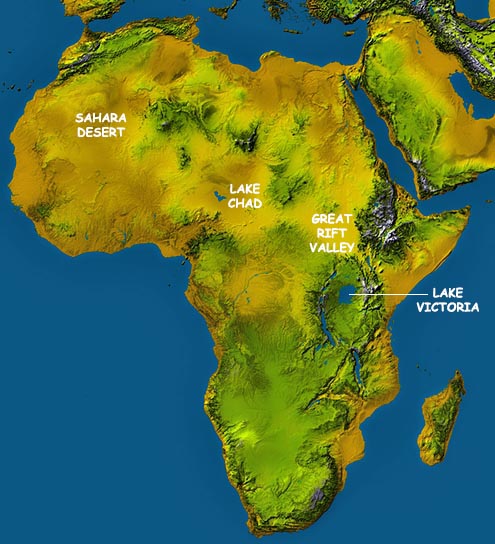
A topographic map highlights hills, mountains and valleys of a specific land area by exaggerated shading rather than by using contour lines. This topo map clearly shows the flatness of the Sahara Desert, the depression that Lake Chad sits in, the high mountains of the Great Rift Valley, and it also highlights Lake Victoria, all but surrounded by mountains.
GREAT RIFT VALLEY MAP
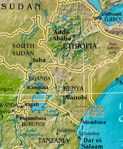
This is a slice of a larger topographical map that highlights the Great Rift Valley, a dramatic depression on the earth's surface, approximately 4,000 miles (6,400 km) in length, extends from the Red Sea area near Jordan in the Middle East,, south to the African country of Mozambique. In essence, it's a series of geological faults caused by huge volcanic eruptions centuries back, that subsequently created what we now call the Ethiopian Highlands, and a series of perpendicular cliffs, mountain ridges, rugged valleys and very deep lakes along its entire length. Many of Africa's highest mountains front the Rift Valley, including Mount Kilimanjaro, Mount Kenya and Mount Margherita.
Atlas Mountains:
This mountain system runs from southwestern Morocco along the Mediterranean coastline to the eastern edge of Tunisia. Several smaller ranges are included, namely the High Atlas, Middle Atlas and Maritime Atlas. The highest peak is Mt. Toubkal in western Morocco at 13,671 ft. (4,167 m).
Congo River Basin:
The Congo River Basin of central Africa dominates the landscape of the Democratic Republic of the Congo and much of neighboring Congo. In addition, it stretches into Angola, Cameroon, the Central African Republic and Zambia. The fertile basin is about 1,400,000 sq. miles (3,600,000 sq. km) in size and contains almost 20% of the world's rain forest. The Congo River is the second longest river in Africa, and it's network of rivers, tributaries and streams help link the people and cities of the interior.
Ethiopian Highlands:
The Ethiopian Highlands are a rugged mass of mountains in Ethiopia, Eritrea (which is sometimes referred to as the Eritrean Highlands), and northern Somalia in the Horn of Africa. The Ethiopian Highlands form the largest continuous area of its altitude in the whole continent, with little of its surface falling below 1500 m (4,921 ft), while the summits reach heights of up to 4550 m (14,928 ft). It is sometimes called the Roof of Africa for its height and large area.
Great Rift Valley:
A dramatic depression on the earth's surface, approximately 4,000 miles (6,400 km) in length, extends from the Red Sea area near Jordan in the Middle East, south to the African country of Mozambique. In essence, it's a series of geological faults caused by huge volcanic eruptions centuries back, that subsequently created what we now call the Ethiopian Highlands, and a series of perpendicular cliffs, mountain ridges, rugged valleys and very deep lakes along it's entire length. Many of Africa's highest mountains front the Rift Valley, including Mount Kilimanjaro, Mount Kenya and Mount Margherita.
Hoggar (Ahaggar) Mountains:
The Hoggar Mountains, also known as the Ahaggar, are a highland region in central Sahara, or southern Algeria, along the Tropic of Cancer. They are located about 1,500 km (900 mi) south of the capital, Algiers and just west of Tamanghasset. The region is largely rocky desert with an average altitude of more than 900 metres (2,953 feet) above sea level. The highest peak is at 3,003 meters (Mount Tahat).
Kalahari Desert:
It's about 100,000 sq. miles (259,000 sq. km) in size and covers much of Botswana, the southwestern region of South Africa and all of western Namibia. The desert plateau is criss-crossed by dry rivers beds and dense scrub. A few small mountain ranges are situated here including the Karas and the Huns. Large herds of wildlife are found in the Kalahari Gemsbok National Park, located in South Africa near its border with Namibia.
Namib Desert:
The Namib is a coastal desert in southern Africa that stretches for more than 2,000 km (1,200 mi) along the Atlantic coasts of Angola, Namibia, and South Africa, extending southward from the Carunjamba River in Angola, through Namibia and to the Olifants River in Western Cape, South Africa. From the Atlantic coast eastward, the Namib gradually ascends in elevation, reaching up to 200 km (120 mi) inland to the foot of the Great Escarpment.
Annual precipitation ranges from 2 mm (0.079 in) in the most arid regions to 200 mm (7.9 in) at the escarpment, making the Namib the only true desert in southern Africa. The Namib is also the oldest desert in the world and its geology consists of sand seas near the coast, while gravel plains and scattered mountain outcrops occur further inland.
The desert's sand dunes, some of which are 300 m (980 ft) high and span 32 km (20 mi) long, are the second largest in the world after the Badain Jaran Desert dunes in China
Nile River System:
The longest river in the world (flows north), rising from the highlands of southeastern Africa and running about 4,160 miles (6,693 km) in length, to then drain in the Mediterranean Sea. In simple terms it's a series of dams, rapids, streams, swamps, tributaries and waterfalls. Numerous (major) rivers comprise the overall system, including the Albert Nile, Blue Nile, Victoria Nile and White Nile.
Sahel:
The Sahel is a wide stretch of land running completely across north-central Africa, just on the southern edges of the ever-expanding Sahara Desert. This border region is the transition zone between the dry areas of the north and the tropical areas of the south. It receives very little rain (six - eight inches a year) and most of the vegetation is a savanna growth of sparse grasses and shrubs.
Sahara Desert:
Covering almost one-third of the continent, the Sahara is the largest desert in the world at approximately 3,500,000 sq. miles (9,065,000 sq. km) in total size. Topography includes areas of rock-strew plains, rolling sand dunes and numerous sand seas.
It ranges in elevation from 100 ft. below sea level, to peaks in the Ahaggar and Tibesti mountains that exceed 11,000 ft. (3,350m). Regional deserts include the Libyan, Nubian and the Western desert of Egypt, just to the west of the Nile.
Almost completely without rainfall, a few underground rivers flow from the Atlas Mountains, helping to irrigate isolated oases. In the east, the water's of the Nile help fertilize smaller parts of the landscape.
- Continent Size: 30,221,532 sq km, 11,668,599 sq miles
The only continent larger in area is Asia - Percent of Earth's Land: 12.7%
- Highest Point: Mt Kilimanjaro, Tanzania, 19,341 ft (5,895m) (see map)
- Lowest Point: Lake Assal, Djibouti (-512 ft) (-156 m) (see map)
- Geographic Center: The geographic center of Africa is located within Lobeke National Park in far southeastern Cameroon at 2° 37' N 16° 06' E. (see map)
- Horizontal Width: 4,355 miles (7,009 km) from Dakar, Senegal, east to Mogadishu, Somalia (see map)
- Vertical Length: 4,504 miles (7,248 km) from Cape Town, South Africa north to Tripoli, Libya: (see map)
Largest African Countries: (by land area)
- Algeria: 2,381,741 sq km
- Congo, DRC: 2,344,858 sq km
- Sudan: 1,861,484 sq km
- Libya: 1,759,540 sq km
- Chad: 1,284,000 sq km
- Niger: 1,267,000 sq km
- Angola: 1,246,700 sq km
- Mali: 1,240,192 sq km
- South Africa: 1,221.037 sq km
- Ethiopia: 1,104,300 sq km
No comments:
Post a Comment