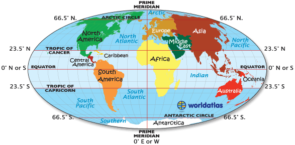
On the map shown, and for that matter on all other maps, the Arctic Circle, Antarctic Circle, Equator, Prime Meridian, Tropic of Cancer and Tropic of Capricorn are imaginary lines.


NOTE: The position of the Arctic and Antarctic Circles are not fixed, as their exact location depends on the Earth's axial tilt, which fluctuates within a margin of 2° over a 40,000 year period, mainly due to tidal forces resulting from the orbit of the Moon.


People living North of the Tropic of Cancer and South of the Tropic of Capricorn experience dramatic seasonal climate changes, based on the earth's tilt, and the subsequent angle of the sun. When it's summer North of the Tropic of Cancer, it's winter South of the Tropic of Capricorn. (The reverse is also true).


The planet's four hemispheres are each shaded a dark gray.

The Equator, that imaginary horizontal line at 0º degrees latitude at the center of the earth, divides the earth into the Northern and Southern Hemispheres.

The vertical imaginary line called the Prime Meridian, at 0º degrees longitude, and its twin line of longitude, opposite the Prime Meridian at 180º longitude, divides the earth into the Eastern and Western Hemispheres.

Therefore (with some exceptions) all countries north of the Equator are in the Northern Hemisphere, while all countries south of the Equator are in the Southern Hemisphere. In addition, all countries west of the Prime Meridian are in the Western Hemisphere while those east of the Prime Meridian are in the Eastern Hemisphere.

Generally the Eastern Hemisphere includes most of Africa, about half of Antarctica, all of Asia and Australia/Oceania, and most of Europe
The Western Hemisphere includes about half of Antarctica and all of North and South America which includes the Caribbean and Central America as well as Greenland.

The Northern Hemisphere includes all of North America, the northern reaches of South America, about two-thirds of Africa, all of Asia excluding (parts of Indonesia) and all of Europe.

The Southern Hemisphere includes most of South America, one-third of Africa, all of Antarctica, a small sliver of Asia (parts of Indonesia) and all of Australia/Oceania.

There are exceptions as some continents (and their countries) based on the straight line divisions of the Equator and Prime Meridian are a part of two hemispheres. For a map and list of countries in both the Eastern and Western Hemispheres, go here, and for countries in both the Northern and Southern Hemispheres, try this page.


Latitude (shown as a horizontal line) is the angular distance, in degrees, minutes, and seconds of a point north or south of the Equator. Lines of latitude are often referred to as parallels.

Longitude (shown as a vertical line) is the angular distance, in degrees, minutes, and seconds, of a point east or west of the Prime (Greenwich) Meridian. Lines of longitude are often referred to as meridians.

Distance between Lines If you divide the circumference of the earth (approximately 25,000 miles) by 360 degrees, the distance on the earth's surface for each one degree of latitude or longitude is just over 69 miles, or 111 km. Note: As you move north or south of the equator, the distance between the lines of longitude gets shorter until they actually meet at the poles. At 45 degrees N or S of the equator, one degree of longitude is about 49 miles.

Minutes and Seconds For precision purposes, degrees of longitude and latitude have been divided into minutes (') and seconds ("). There are 60 minutes in each degree. Each minute is divided into 60 seconds. Seconds can be further divided into tenths, hundredths, or even thousandths.

For example, our office on Galveston Island, Texas, USA, is located at 29 degrees, 16 minutes, and 22 seconds north of the equator, and 94 degrees, 49 minutes and 46 seconds west of the Prime Meridian.

Relative Location of a city or destination on the planet is its relationship to another place or nearby landmarks.

As an example, our U.S. office is on Galveston Island, located in southeastern Texas in the Gulf of Mexico, about 48 miles southeast of Houston. That's our relative location.


Absolute Location is the definitive location of a place using a recognized coordinate system. In terms of latitude and longitude, our office in Galveston, Texas, is 29°16' North, 94°49' West, marked with the red dot on the map above

No comments:
Post a Comment