As the largest and most populous continent in the world with just over 3.8 billion people, Asia is composed of a wide variety of ethnic groups, cultures, environments, economics, historical ties, and governmental systems.
Geographically the continent makes up 8.7% of the Earth's total surface area, and 29.5% of its land area.
In the west, Asia is bordered by Europe, the eastern coastline of the Mediterranean Sea, as well by the Sea of Marmara, the Bosporus Strait, the Black Sea and the Caspian Sea.
In the east, Asia is bordered by the Pacific Ocean, and an almost endless stretch of bays and seas.
The Arctic Ocean and a handful of seas front the northern border, while the Bering Sea separates Asia from North America. In the southwest the Red Sea and isthmus of Suez separate the continent from Africa.
The Indian Ocean fronts most of Asia's southern borders, along with a series of bays, gulfs and seas, as well as extensive chains of both inhabited and uninhabited islands.

Asia Geography Notes:
Burma: Military authorities have promoted the name Myanmar since 1989 as the conventional name for their state. That decision was not (and is not) approved by any sitting legislature in Burma, and is not accepted by the U.S. government. However, Myanmar is widely accepted by numerous countries, and by the United Nations.
European Russia: The Russian landmass west of the Ural Mountains is commonly referred to as European Russia in most educational atlases, and by the vast majority of geography experts. It is not a separate country, but rather called that because of its political, cultural and geographical blendings with Europe. For reference purposes it is shown above to the west of the dashed-line, however, the entire country (as a whole) is still considered part of the continent of Asia.
Middle East: Countries considered part of the Middle East (or West Asia) are shown in a lighter shade of gray. Note that they are all still a part of the continent of Asia.
Opinions vary as to what countries make up the modern definition of Asia and the Middle East. Historically, Armenia and Azerbaijan have been long associated with the Middle East, but in recent years, some sources now consider them to be more closely aligned with Europe based on their modern economic and political trends. We have moved in that direction, and the same can be said for the island country of Cyprus.
Taiwan is still considered by China to be its 23rd province, and not an independent country. Very few other country governments accept China's claims of sovereignty over Taiwan.
Turkey is officially, politically and geographically considered part of both Asia and Europe. The small northwestern portion of Turkey named (Thrace) is a recognized part of Europe, while the largest part (Anatolia) is located in the Middle East, a part of Asia.
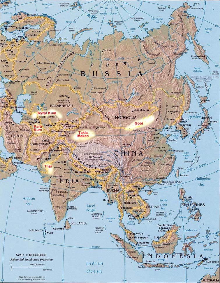
ASIA DESERTS: Several significant deserts stretch across Asia and the Middle East. Here we highlight on the map and briefly describe the major ones, including the Arabian, Gobi, Karakum, Kyzylkum, Takla Makan and Thar.
Arabian Desert
The Arabian Desert is a vast desert wilderness stretching from Yemen to the Persian Gulf and from Oman to Jordan and Iraq. This desert is located in the Middle East, and we have additional details and map at this link:
Gobi Desert
The Gobi Desert is the largest desert in Asia, covering 500,000 square miles. Extending from northern China into Mongolia, the Gobi Desert receives an average of 7 inches of rainfall each year because the Himalaya mountains block rain clouds from reaching the region.
Kara Kum Desert
The Kara Kum covers 135,000 square miles, nearly 70 percent of Turkmenistan's land. Because of the desert's location along the Caspian Sea, the weather in Karakum is milder than many Asian deserts, which typically experience frigid winters and scorching summers.
Kyzyl Kum Desert
Crossing over Kazakhstan into Uzbekistan, this 115,000 square mile desert features a wide variety of flora and fauna. Though the area only receives 4 to 8 inches of rain per year, the rain occurs during the region's cooler period so the water does not dissipate quickly and supports large migratory game.
Takla Makan Desert
China's largest desert extends over 123,550 square miles. Composed primarily of shifting crescent sand dunes, the Takla Makan is one of the largest sandy deserts in the world. Despite the inhospitable and unpredictable nature of the desert sands, the Chinese government erected a road across the desert in the mid-1990s.
Thar Desert
Covering 77,000 square miles in India and Pakistan, the Thar Desert is Asia's only subtropical desert. Primarily occupying the Indian state of Rajasthan, the Thar receives up to 20 inches of rain per year, primarily during the monsoon period from July to September, and most crops are grown during this rainy season.
ASIA LAKES: Dozens of significant lakes are found in Asia. Here we highlight a few on the map and (briefly) describe the three most significant including the Caspian Sea, Lake Baikal and the Aral Sea.
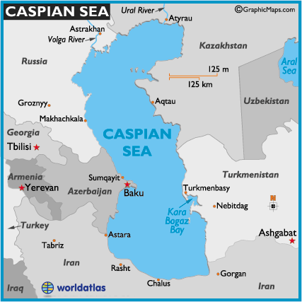
Caspian Sea
The Caspian Sea, located in western Asia on the eastern edges of Europe, is the largest lake on the planet. History records that it's called a sea because the Romans found it salty, especially in the southern reaches, and the name stuck. Oil and natural gas production platforms are replete along the edges of the sea. In addition, large quantities of sturgeon live in its waters, and the caviar produced from their eggs is a valuable commodity. Fresh water flows into the sea via the Volga River and Ural River in the north, however, the sea remains somewhat salty, central and southThe measured surface area is 371,000 sq km (143,244 sq mi), and the maximum depth is at 1025 m (3,363 ft). Additional details and map.

Lake Baikal
Lake Baikal is positioned in southeastern (Siberia) Russia, directly to the north of Mongolia. Recognized as the oldest (still existing) freshwater lake on the planet, it is also measured as the deepest continental body of water at 5,315 feet (1,620 m). In addition, it is the largest freshwater lake by volume, containing an astounding 20% of the planet's fresh water. With a maximum width of 60 miles (96 km), Lake Baikal is about 389 miles (626 km) in length. Completely surrounded by mountains, over 300 rivers and streams drain into this massive lake. Detailed map.
Aral Sea
Positioned in far-western Asia, just to the east of the Caspian Sea, the Aral Sea is located in the countries of Kazakhstan and Uzbekistan. The Aral Sea is disappearing (evaporating) and is today almost totally polluted by fertilizer runoff, weapon testing residue left here by the former Soviet Union and careless industrial projects. The mismanagement of its valuable waters is consider by many experts to be one of the world's worst environmental disasters. Diversion of the Amu Darya and Syr Darya rivers for irrigation began in 1918, and that action, along with other factors have now shrunk the Aral Sea to almost 60% of its former size. Over the last few years the outlook for the northern reaches of the sea have brightened some, but the lower half is basically abandoned and the remaining western waters are now predicted to be gone within a decade.
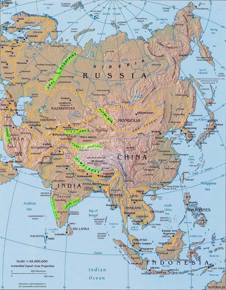
ASIA MOUNTAINS: Several significant mountain ranges stretch across Asia. Here we highlight on the map and describe the major ones, including the Altay, Gahats, Himalayan, Kunlun, Tien Shan, Ural and Zagros Mountains
Altay (or Altai)
The Altay Mountains are a mountain range in East-Central Asia, where Russia, China, Mongolia and Kazakhstan come together, and where the rivers Irtysh and Ob have their sources. Belukha Mountain is the highest peak at 4,506 m, (14,784 ft).
Ghats
The Western Ghats are a mountain range along the western side of India with an average elevation around 1,200 m, (3,900 ft). The Eastern Ghats are a range of mountains along India's eastern coast. The highest point is Jindhagada Peak at 1,690 m (5,545 ft).
Himalayas
The Himalayas, a huge mountain range immediately at the north of the Indian subcontinent, is the world's highest mountain range, and home to the world's highest peaks, including Mount Everest at 8,848 m (29,029 ft), and K2 at 8,611 m (28,251 feet) above sea level. The Himalayan system includes over 100 mountains exceeding 7,200 m (23,600 ft).
Kunlun
The Kunlun Mountains are one of the longest mountain chains in Asia, extending across wester China and the Tibetan Plateau. The highest mountain is the Kunlun Goddess at 7,167 m (23,514 ft).
Tien (or Tian) Shan
The Tian Shan is a large mountain system located in Central Asia. It's positioned to the north and west of the Taklamakan Desert near the border region of Kazakhstan, Kyrgyzstan and western China. The highest peak is Victory Peak at 7,439 m (24,406 ft).
Ural
The Urals are 1,640 miles (2,640 km) in length and extend from the northern-edge of the Russian Federation down through Kazakhstan. They form a natural border between Asia and Europe Russia. The highest point in this mountain range is Mt. Narodnaya at 1,895 m (6,217 ft).
Zagros
The Zagros are the largest mountain range in Iran and Iraq spaning the whole length of the western and southwestern Iranian plateau and ending at the Strait of Hormuz. The highest point is Zard Kuhbakhtiari at 4,548 m, (14,921 ft).
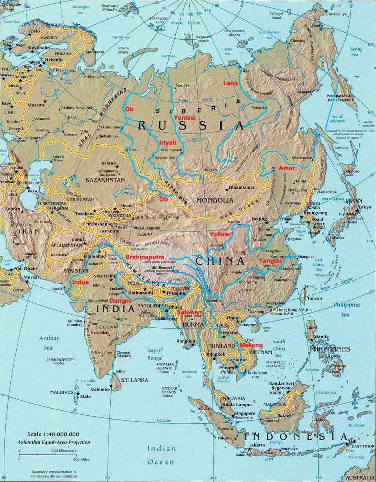
ASIA RIVERS: Dozens of significant rivers rise in Asia. Here we highlight a few on the map and (briefly) describe some of the most significant ones, including the Ganges, Indus, Lena, Mekong, Ob, Yangtze and Yellow.
Ganges
The Ganges is the most sacred river to Hindus and is also a lifeline to millions of Indians who live along its course and depend on it for their daily needs. It is 1,560 miles (2,510 km) in length.
Lena
The Lena is the easternmost of the three great Siberian rivers that flow into the Arctic Ocean (the other two being the Ob River and the Yenisei River). It is the 11th longest river in the world at 2,734 miles (4,400 km).
Indus
The Indus River originates in Tibet and flows through India and Pakistan. It provides water resources for the economy of Pakistan - especially the Breadbasket of the southeast, which accounts for most of the nation's agricultural production. It is 1,800 miles (2,900 km) in length.
Mekong
The Mekong is the world's 10th-longest river and the 7th-longest in Asia. Its estimated length is 3,050 (4,909 km) and it provides inland transportation for the millions living along its banks, and tributaries
Ob
The Ob is a major river in western Siberia, Russia. The Ob is used mostly for irrigation, drinking water, hydroelectric energy, and fishing. It's 2,268 miles (3,650 km) in length.
Yangtze
China's Yangtze is the longest river in Asia, and the fourth longest in the world at 3,915 miles (6,301 km). The Yangtze drains one-fifth of the land area of the People's Republic of China and its river basin is home to one-third of China's population.
Yellow
The Yellow River is the second-longest river in China and the sixth-longest in the world at 3,395 miles (5,464 km) in length. It's called "the cradle of Chinese civilization" as its basin – specifically, the Wei valley – was the birthplace of ancient Chinese civilizations and the most prosperous region in early Chinese history.
Middle East Landforms -
Anatolian Plateau:
This generally barren and arid plateau of central Turkey averages about 500 meters in elevation. Farming and livestock raising (the major industries), are difficult occupations here as extreme temperatures, both summer and winter are commonplace. Regardless, scattered towns and villages cover the landscape.
An Nafud Desert:
Part of the Arabian Desert, this desert of western Saudi Arabia is famous for gigantic sand dunes, some reaching over 100 ft.high.
Ar Rub' Al Khali Desert:
Known as the Empty Quarter, it's the largest (only sand) desert in the world and famed for huge sand dunes that can extend for over 25 miles. A large part of the Arabian Desert, it covers most of southern Saudi Arabia, and is almost moistureless. The Ad Dahna' is the northern expanse that connects to the An Nafud Desert.
Arabian Desert:
The Arabian Desert, one of the largest deserts on the planet, is a vast desert wilderness stretching from Yemen to the Persian Gulf and from Oman to Jordan and Iraq. It occupies most of the Arabian Peninsula, with an estimated area of 2,330,000 sq km (900,000 sq mi).
Asir & Hejaz Mountains:
Running along Saudi Arabia's border with the Red Sea, these two ranges of lower mountains averages 6,000 - 7,000 ft. (1,829 - 2,130 m)
Caucasus Mountains:
Positioned between the Black and Caspian Seas, these mountains dominate the landscape of Armenia, Azerbaijan and Georgia where the Middle East begins. Volcanic peaks here exceed 15,000 ft., with the highest point being Mt. Elbrus at 18,481 ft. (5,633m).
Dash e -Lut:
Known as the Lout Desert, this region of eastern Iran is an arid, wind-blown desert, completely surrounded by mountains. In the summer months, it can be one of the hottest and driest spots on the planet. In some areas here rain has never been measured.
Dash e -Kavir:
This plateau of north-central Iran is often referred to as the "Great Salt Desert." It's the largest desert in the country and is mostly uninhabited wasteland covered with crusty salt ridges.
Elburz Mountains:
Extending for almost 620 miles along Iran's northern border with the Caspian Sea, these jagged mountains average over 9,000 ft, with the highest point being Mt. Damavand, a dormant volcano, at 18,602 ft. (5,670m).
Hadramawt
This low mountain range (and region) of Yemen averages about 3,500 ft. (1,067m), with the highest peak estimated at 8,000 ft. (2,440m).
Hindu Kush
These dramatic mountains form a natural border between Afghanistan and Pakistan, with many snow-capped peaks reaching over 22,000 ft. The highest point is Tirich Mir at 25,282 ft. (7,706m).
Kara Kum Desert
This desert of south-central Turkmenistan is a large mass of sand known for its towering sand dunes extending in all directions. It's about 115,000 sq. miles in size.
Pamir:
This region and its namesake mountains stretch across much of Tajikistan and parts of Afghanistan, China and Pakistan, and similar to the Hindu Kush, numerous peaks exceed 22,000 ft, with the highest point being Pik Samani at 24,590 ft. (7,495m).
Syrian Desert:
A part of the Arabian Desert, and 200,000 sq, miles (518,000 sq, km) in size, it covers parts of Jordan, Syria, Saudi Arabia and western Iraq. Very little rain falls in this wasteland, however, Arab nomads inhabit the desert, raising cattle and camels. Oil pipelines are commonplace, as well as scattered oases.
Taurus Mountains:
This rugged chain extends across southern Turkey to its borders with Iraq and Iran. The highest point (Mt. Ararat) is located in the Eastern Taurus range. This extinct volcano is 16,583 ft. (5,137m) high. It is felt by biblical historians that Noah's Ark landed here. The Koroglu and Ponic ranges stretch along the Black Sea coast of northern Turkey.
Tien Shan:
Stretching almost 1,500 miles across Kyrgyzstan and well into China, this multiple range of mountains (also known as Tian) commonly exceed 19,000 ft., with the highest point being Pik Pobeda at 24,407 ft. (7,439m).
Zagros Mountains:
This region and its namesake mountains stretch across much of Tajikistan and parts of Afghanistan, China and Pakistan, and similar to the Hindu Kush, numerous peaks exceed 22,000 ft, with the highest point being Pik Samani at 24,590 ft. (7,495m).
Dozens of rivers are found in the Middle East (Asia). Most are small, so here we highlight the four major ones, and offer a brief description.
Amu Darya:
This river flows from a high plateau in the Pamir Mtns. of central Asia, across southern Tajikistan, forming its border with Afghanistan, then northwest, forming parts of the borders between Turkmenistan and Uzbekistan and on into the Aral Sea. It's (1,578 miles) (2,539 km) in length. In ancient times the Amu Darya was called the Oxus. It was part of Persia, and played a significant role in the military campaigns of Alexander the Great.
Euphrates:
From the Caucasus Mtns of Armenia, it flows southwesterly across east-central Turkey, then generally southeast through Syria and Iraq, ending in the waters of the Persian Gulf. It joins with the Tigris in southern Iraq, and from that junction continues on as the Shatt al Arab. Overall it's (2,235 miles) (3,596 km) in length, and is certainly the longest river in the Middle East. Historically important in ancient history, the once great city of Babylon stood on its banks.
Indus:
It begins in the high mountains of Tibet (southwestern China), flowing northwest through the Jammu & Kashmir region of India and Pakistan, then generally south through Pakistan, ending in the Arabian Sea. The Indus, through a series of dams and canals, provides much of the irrigation and power for central Pakistan. It's (1,800 miles) (2,896 km) in length.
Tigris:
Rising in the mountains of southern Turkey, the Tigris flows southeast through Iraq, where in the southern part of that country it merges with the Euphrates to become the Shatt al Arab, which then flows to the Persian Gulf. The river has numerous small tributaries running from its eastern bank, and is (1,180 miles) (1,899 km) in length.
Mediterranean Sea
The Mediterranean Sea was an important route for merchants and travelers during ancient times as it allowed for trade and cultural exchange between emergent peoples of the region.
Several ancient civilizations were located around its shores; thus it has had a major influence on those cultures. It provided routes for trade, colonization and war, and provided food (by fishing and the gathering of other seafood) for numerous communities throughout the ages.
This inland sea is bordered on the north by Europe, the east by Asia, and in the south by Africa. This 969,100 sq. mile body of water is approximately 2,300 miles in length, and has a maximum depth of 16,896 ft.
The typical Mediterranean climate is hot, with dry summers and mild, rainy winters. Major crops of the region include olives, grapes, oranges, tangerines, and cork.
Major subdivisions include the Adriatic Sea, Aegean Sea, Balearic Sea, Tyrrhenian Sea, Ionian Sea and Ligurian Sea.

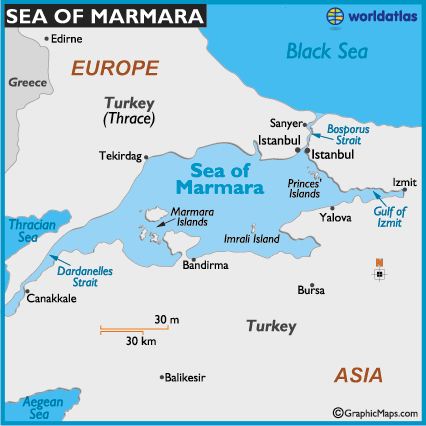
Sea Of Marmara
The Sea of Marmara, a northeastern extension of the Mediterranean Sea, separates Asian Turkey from European Turkey (Trace), thus it separates the two continents.
Bordered completely by Turkey, it connects to the Aegean Sea via the Dardanelles Strait, and to the Black Sea through the Bosporus Strait.
This (somewhat salty) body of water serves as a primary highway for the transport of energy to Europe from Russia and western Asia. In 2005 over 55,000 ships, including almost 6,000 oil tankers passed through it, most carrying Russian oil.
It contains two island groups; the Marmara in the southwest and the Princes' in the northeast. On the small island of Imrali stands a maximum-security prison that holds just a few prisoners, including Abdullah Ocalan, the leader of PKK, a Kurdish terrorist group.
Bosporus Strait
The Bosporus Strait (or Bosphorus) connects the Black Sea to the Sea of Marmara. It also separates Asian Turkey from European Turkey (Trace), thus it separates the two continents.
Bordered on both sides by the massive city of Istanbul, the strait is one of the planet's most strategic waterways.
This body of water serves as a primary highway for the transport of energy to Europe from Russia and western Asia. In 2005 over 55,000 ships, including almost 6,000 oil tankers passed through it, most carrying Russian oil.
Crossed by two large suspension bridges, the strait is just over 2 miles across at its widest point; about 32km (20 miles) in length, and a measured 30-120m (100-395ft) deep
Black Sea
The Black Sea is an inland sea located between far-southeastern Europe and the far-western edges of the continent of Asia and the country of Turkey.
It's bordered by Turkey, and by the countries of Bulgaria, Romania, Ukraine, Russia and Georgia.
It connects to the Mediterranean Sea first through the Bosporus Strait, then through the Sea of Marmara and the Dardanelles Strait, then south through the Aegean Sea and the Sea of Crete.
Many rivers flow into the Black Sea but the two most important include the Danube and the Dnipro.
Excluding the Sea of Azov, the Black Sea is 436,400 sq. km (168,500 sq. miles) in size, and has a maximum depth of 2200 meters (7,218 ft.).
Over many centuries the Black Sea has been of critical importance to regional commerce. Today this body of water serves as a primary highway for the transport of energy to Europe from Russia and western Asia.
This valuable economic conduit is one of the world's busiest waterways, and in 2005 over 55,000 ships, including almost 6,000 oil tankers passed through the Bosporus Strait, most carrying Russian oil.
Caspian Sea
The Caspian Sea, located in western Asia on the eastern edges of Europe, is the largest lake on the planet.
History records that it's called a sea because the Romans found it salty, especially in the southern reaches, and the name stuck.
The measured surface area is 371,000 sq km (143,244 sq mi), and the maximum depth is at 1025 m (3,363 ft).
The sea is bordered by the countries of Azerbaijan, Russia, Kazakhstan, Turkmenistan and Iran.
Oil and natural gas production platforms are replete along the edges of the sea. In addition, large quantities of sturgeon live in its waters, and the caviar produced from their eggs is a valuable commodity.
Fresh water flows into the sea via the Volga River and Ural River in the north, however, the sea remains somewhat salty, central and south.