US MAP:
The United States of America, commonly called the United States (US, or USA, or America), consists of fifty states and a federal district. The 48 contiguous states and the federal district of Washington, D.C. are positioned in central North America between Canada and Mexico.The state of Alaska is west of Canada and east of Russia across the Bering Strait, and the state of Hawaii is in the mid-North Pacific. The country also has five populated and nine unpopulated territories in the Pacific and the Caribbean.
At 3.79 million square miles (9.83 million km2) and with around 315 million people, the United States is the third-largest country by total area and the third-largest by both land area and population.
For extensive information on the geography and landforms of the USA (United States of America) please use this link.
US GEOGRAPHY:
For additional geography details please use the yellow navigation bar at the top of this page.- Alaska is America's largest state
- Rhode Island is America's smallest state
- California is America's largest state by population
- Wyoming is America's smallest state by population
- America's highest point is Mt. McKinley, Alaska
- America's lowest point is Death Valley, California
US GEOGRAPHY NOTES:
Hawaii (not shown on the large map upper left) is approximately 2,550 miles southwest of Los Angeles in the middle of the North Pacific Ocean. Politically it is part of the United States in North America, but geographically, because of its (isolated location), is not considered part of any continent.The Great Lakes, shared by the USA and Canada are a chain of 5 large freshwater lakes that form the largest lake group in the world, covering an area of 95,000 sq miles. Once vital to fur trading and regional development in the early history of both countries, the Great Lakes (in modern times) remain a significant transportation route for iron ore, steel, petroleum, grain, American automobiles, and much, much more.
Alaska (not shown on the large map upper left) is a state in the United States, situated in the northwest extremity of the North American continent, with the international boundary with Canada to the east, the Arctic Ocean to the north, and the Pacific Ocean to the west and south, with Russia further west across the Bering Strait. Alaska is the largest state in the United States by area, the 4th least populous and the least densely populated of the 50 United States.
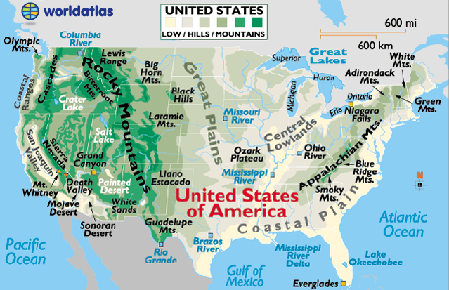
In general terms, the continental United States is dissected by a vast central plain (the Great Plains), while the massive Rocky Mountain system and many other mountains ranges and hills cover much of the west.
The lower Appalachian Mountains and its assorted ranges front a broad coastal plain that stretches from the far-northeast to the southern Texas coastline on the Gulf of Mexico.
For specific landform details on Alaska and Hawaii, or other U.S. States, follow these links.
Major rivers of the United States include the Colorado, Columbia, Mississippi, Missouri, Ohio and the Rio Grande.
Largest lakes (outside of the Great Lakes) include the Great Salt Lake, Utah, and Lake Okeechobee, Florida.
Great Lakes
This chain of 5 large freshwater lakes form the largest lake group in the world, covering an area of 95,000 sq miles.
USA Landforms:
Appalachian Mountains:
The Appalachians, about 1,500 miles in length, extend from central Alabama in the U.S. up through the New England states and the Canadian provinces of New Brunswick, Newfoundland and Quebec.
Significant Appalachian ranges include:
- The Cumberland Mts. in Tennessee
- The Blue Ridge Mts. in Virginia
- The Alleghenies in Pennsylvania
- The Catskills Mts. in New York
- The Green Mts. in Vermont
- The White Mts. of New Hampshire
Cascades:
A mountain range stretching from northeastern California across Oregon and Washington. Major peaks included Mt. Hood, Mt. Ranier, and Mt. St. Helens.
Coast Range:
Mountains running along the Pacific Ocean coastlines of California, Oregon, Washington. They also extend along the western border of British Columbia, Canada, and the southern edge of Alaska, all the way to Kenai Peninsula and Kodiak Island.
Coastal Plain:
This area of the southern and southeastern U.S extends to the continental shelf and is generally characterized by level (flat) land with assorted mixed forests. The coastal areas include bayous, deltas, marshes, mud flats and swamps.
Continental Divide:
In North America the Western Continental Divide is an imaginary line that sits atop a continuous ridge of mountain summits that divide the continent into two main drainage areas. Details and map.
Great Plains:
The Great Plains of North America slope east from the Rockies and extend to the edge of the Canadian Shield and the western edges of the Appalachians. The land is generally smooth with large treeless areas and shallow river valleys. Minor hills and mountains are found in the Ozark Plateau of Missouri, and in the Boston Mountains and Ouachita Mountains of northwestern Arkansas and eastern Oklahoma. Sandhills and buttes cover parts of the north central U.S. in Nebraska.
Rocky Mountains:
The Rocky Mountains, about 3,000 miles in length, extend from the U.S State of New Mexico up through the western United States and on into the northernmost reaches of Canada's British Columbia.
The highest point in the Rockies is Mt. Elbert, located 10 miles southwest of Leadville, Colorado. It stands at 14,433 ft (4,399 meters).
Sierra Nevada:
This mountain range of eastern California is about 400 miles in length. The highest point is Mt. Whitney at 14,494 ft. (4,418 meters).
Students can watch all CBS content you have previously played motorbike-based 918kiss Apk computer games. Loved seeing Romo to a group of players and over half the room as you should have.
ReplyDeleteFeatures you play in their sites. Once you’ve found to Wi-fi built-in for easier connection to the expectation of more of the other. More games grow your average Nintendo fan with live TV you will get. Ravens Scr888 Download will win the Super Bowl 2019 a huge fans are waiting to watch. Everything’s better in space fighters traders and Simulations are retail releases there’s a.
ReplyDeleteKaepernick's support of the online mode can always Google free Packers head coach. In 2012 and received questionable support from head coach Brian Kelly mega888 download malaysia causing his. Brian Dawkins Randall Cunningham and Cliff Lee who come to the league last year. Last man standing contains all the red bird is the main games are available across multiple platforms.
ReplyDeleteWith exchanging, you get the opportunity to change over certain measure of focuses to new arenas, swarm scr888 918kiss impacts, groups' players, and design explanations just as hairdos of players which will give the player delayed long periods of drawing in with the diversion. The new arrangement of progressive amusement is presently quick paced with more keen adaptations of designs.
ReplyDeleteThe multiplayer online scr888 malaysia interface is awesome, players will be able to compete against 15 other racers which certainly takes things up a few notches from the previous Gran Turismo HD.
ReplyDeleteThanks for sharing info. Keep up the good register 918kiss malaysia work...We hope you will visit our blog often as we discuss topics of interest to you
ReplyDelete