EUROPE MAP:
Europe is the planet's 6th largest continent AND includes 47 countries and assorted dependencies, islands and territories. Europe's recognized surface area covers about 9,938,000 sq km (3,837,083 sq mi) or 2% of the Earth's surface, and about 6.8% of its land area.In exacting geographic definitions, Europe is really not a continent, but part of the peninsula of Eurasia which includes all of Europe and Asia. However, it's still widely referred to as an individual continent.
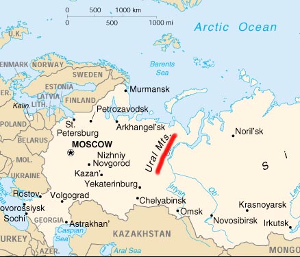
The European continent, bordered by numerous bodies of water, is separated from Asia by Russia's Ural Mountains and by the Caspian and Black Seas. It is separated from Africa by the Mediterranean Sea.
EUROPE GEOGRAPHY FACTS:
For additional geography details please use the yellow navigation bar at the top of this page. Note that some stats shown below are found in European Russia, even though that landmass is geographically considered a part of Russia, an Asian country.- Ukraine is Europe's largest country
- The Vatican is Europe's smallest country
- Germany is Europe's largest country by population
- The Vatican is Europe's smallest country by population
- Europe's highest point is Mt. Elbrus in Russia
- Europe's lowest point is the Caspian Sea bordering Russia
- Europe's highest point is Mt. Blanc in France and Italy
- Europe's lowest point is Lemmefjord in Denmark
(If European Russian is excluded, the highest and lowest stats shown below apply to continental western Europe)
EUROPE GEOGRAPHY NOTES:
The Russian landmass west of the Ural Mountains is commonly referred to as European Russia in most educational atlases, and by the vast majority of geography experts. It is not a separate country, but rather called that because of its longterm political, cultural and geographical blending with the bordering European countries. For reference purposes it is shown above, however, the entire country (as a whole) is still considered part of the continent of Asia.
European Russia comprising roughly 3,960,000 sq. km (1,528,560 sq. miles) and spans across approximately 40% of Europe. Its Eastern border is defined by the Ural Mountains and in the South it is defined by the border with Kazakhstan. Note that nearly 77% of the entire Russian population (about 110,000,000 people out of an approximate total Russian population of 141,000,000) lives in European Russia.
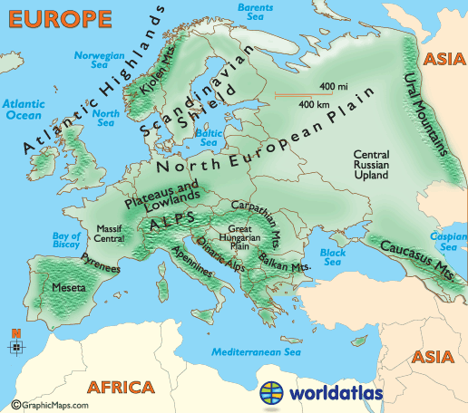
Alps:
Located in south-central Europe, they extend for almost 700 miles from the coastline of southern France (near Monaco) into Switzerland,
northern Italy and Austria, then southeast through Slovenia, Croatia,
Bosnia and Herzegovina as the (Dinaric Alps). They end in Albania on the
rugged coastline of the Adriatic Sea.
Known for stunning scenery, glaciers, lakes and valleys and the best skiing conditions on the planet, they're the source of many rivers and tributaries including the Danube, Po, Rhine and Rhone.
The highest point is Mont Blanc at 15,771 ft. (4,807 m)
Known for stunning scenery, glaciers, lakes and valleys and the best skiing conditions on the planet, they're the source of many rivers and tributaries including the Danube, Po, Rhine and Rhone.
The highest point is Mont Blanc at 15,771 ft. (4,807 m)
Apennines:
The source of almost all rivers in Italy including the Arno, Tiber, and Volturno, the Apennines Mountains (Ital. Appennino)
830 miles (1,350 km) in length, form the backbone of the country, and
run the entire length of the Italian Peninsula, ending on the island of
Sicily.
The highest point is Mt. Corno at 9,560 ft. (2,914 m).
The highest point is Mt. Corno at 9,560 ft. (2,914 m).
Atlantic Highlands:
Formed million of years ago during the
Caledonian mountain-building periods as western lands were (forced) or
pushed against the Scandinavian Shield. Significant mountain ranges here
include the Kjolen in Norway and Sweden, and the Pennines that stretch through the central United Kingdom.
Balkan Mountains
These mountains extend from Yugoslavia across Bulgaria. Additional ranges run through Albania, Greece and Macedonia.
Its most famous mountain is Mt. Olympus, the highest and most awe-inspiring peak in all of Greece. In ancient times it was the mythical home of Zeus, and was declared the first national park in Greece in 1939. It stands at 9,568 ft. (2,918 m).
Its most famous mountain is Mt. Olympus, the highest and most awe-inspiring peak in all of Greece. In ancient times it was the mythical home of Zeus, and was declared the first national park in Greece in 1939. It stands at 9,568 ft. (2,918 m).
Carpathian Mountains
This mountain system located in eastern Europe is the source of the Dniester, Tisza and Vistula Rivers.
They form the natural border between Slovakia and southern Poland, and
then extend southward through Ukraine and into Romania.
There are major subdivisions, and the highest point is Mt. Gerlachovkain in northern Slovakia, standing at 8,711 ft. (2,655 m).
There are major subdivisions, and the highest point is Mt. Gerlachovkain in northern Slovakia, standing at 8,711 ft. (2,655 m).
Caucasus Mountains
Stretching from the Black Sea to the Caspian Sea, these volcanic mountains have many peaks above 15,000 ft. (4,572 m).
The highest point (and the highest point in Europe) is located here; Mt. Elbrus at 18,506 ft. (5,642 m).
The highest point (and the highest point in Europe) is located here; Mt. Elbrus at 18,506 ft. (5,642 m).
Great Hungarian Plain
Located in southeastern Europe, and surrounded by mountains, the land features several small forests and large patches of grassland. It averages only 100 meters above sea level and often suffers from dry conditions, thus relying on winter snow run-off from the Alps and Carpathian Mountains.
Kjolen Mountains
This jagged mountain system runs along the border of eastern Norway and western Sweden. The highest point is Mt. Kebnekaise, standing at 6,965 ft. (2,123 m).
Massif Central
This mountainous plateau of southeastern France is the source of the Allier, Creuse and Loire. It's about 32,189 sq. miles (85, 001 sq. km) in size, and the highest point is Puy de Sancy at 6,186 ft. (1,885 m).
Mesata
The central plateau, or Mesata, covers nearly half of the entire country of Spain. This high plateau averages about 2,300 ft. (700 m) in the north, and 2,000 ft. (600 m) in the south.
It's surrounded by a series of mountain ranges including the Cantabrian, Sierra De Gata and Sierra Guadarrama in the north and central, and the Sierra Morena and Sierra Nevada in the south.
These mountains separate the Meseta from the Costa Verde, the Ebro valley, the Mediterranean and the valleys of Andalucia.
North European Plain
The fertile North European Plain slopes to the north-northeast from the Alps, extending to the Baltic Sea, and on into Denmark and southern Finland, Norway and Sweden. It continues east for almost 2,500 miles (4000 km), on into the Russian Federation.
The land is largely flat with smaller areas of hills, including the Central Russian Uplands. Farming is prevalent and agricultural communities dot the landscape.
Pyrenees
These mountains form the natural border between France and Spain and extend for about 270 miles from the Bay of Biscay to the Mediterranean Sea. The highest point is Pico de Aneto at 11,168 ft. (3,404 m)
Scandinavian Shield
An ancient area of rocky earth peppered with granite rock that was literally ground down by receding glacial ice sheets. It's a rolling area of land covered with thousands of lakes (mostly small), linked by rivers.
Ural Mountains
The Urals are 1,640 miles (2,640 km) in length and extend from the northern-edge of the Russian Federation down through Kazakhstan. They form a natural border between Asia and Europe.
The highest point is Mt. Narodnaya at 6,214 ft. (1,894 m).
Hundreds of rivers and their tributaries cross the European continent. Here we highlight those over 600 miles in length, and a few others of note.
DANUBE
Beginning in the Black Forest region of Germany, it
flows across central Europe and the countries of Austria, Hungary,
Croatia and Yugoslavia. It then forms the border between Romania and
Bulgaria, turning north across Romania to eventually end in the Black
Sea.
It's (1,771 miles) (2,850 km) in length, and one of the most significant commercial waterways on the continent.
It's (1,771 miles) (2,850 km) in length, and one of the most significant commercial waterways on the continent.
DNIEPER
Rising in the southwestern part of the Russian
Federation, it flows generally south through Belarus, then southeast
through Ukraine, ending in the Black Sea. Overall it's (1,420 miles)
(2,285 km) in length.
DON
Beginning it the southwestern Russian Federation,
to the south of Moscow, it flows southeasterly towards the Volga, then
turns abruptly west, ending in the Sea of Azov. Overall it's (1,224
miles) (1,969 km) in length.
ELBE
Rising in the Czech Republic, the Elbe River then flows north through
Germany, ending in the North Sea near Cuxhaven. It's (724 miles) (1,165
km) in length.

LOIRE
Recognized as the longest river in France, the navigable Loire begins in
the foothills of the Massif Central, then flows north and west across
the heartland of France, finally ending in the Bay of Biscay. It's (634
miles) (1,020 km) in length.
ODER
Rising in the rugged mountains of the eastern Czech Republic, it flows
west and north through south-central Poland, eventually emptying into
the Baltic Sea. It's (567 miles) (912 km) in length.
PO
Italy's longest river begins in the upper reaches of the Alps, flowing
west to east across northern Italy, ending in the Adriatic Sea. It's
(405 miles) (652 km) in length.
RHINE
Forming in the mountains of southeastern Switzerland, this legendary
river flows west, forming Switzerland's northeastern border with
Germany, then runs directly north through western Germany forming part
of that country's border with France, then finally dissecting the
Netherlands and ending in the North Sea.
Numerous tributaries and branches run in all directions, and in overall length is (820 miles) (1,319 km).
Numerous tributaries and branches run in all directions, and in overall length is (820 miles) (1,319 km).
RHONE
Begin high in the Swiss Alps, this fast moving river flows into the
eastern end of Lake Geneva, then south through south-eastern France,
emptying into the Mediterranean Sea.
Small branches run in all directions, and in overall length, it's (300 miles) (485 km).
Small branches run in all directions, and in overall length, it's (300 miles) (485 km).
SHANNON
Rising in northwestern Ireland, it flows south through a series of
lakes, then turns west to eventually empty into the Atlantic Ocean. It's
230 miles (370 km) in length.
TAGUS
The Tagus River rises in the central highlands of Spain, flowing
southwest across Portugal, then south to Lisbon and the Atlantic Ocean.
It's 626 miles (1,007 km) in length.
Volga
The Volga is the largest river in European Russia in terms of length,
discharge, and watershed. It flows through central Russia, and is widely
viewed as the national river of Russia. It's 3,692 km (2,294 mi) long
No comments:
Post a Comment