Introduction
The environment is our physical surroundings. This includes both human (man-made), social and physical (natural) features. Natural features include soil, the atmosphere, vegetation and wildlife. Human features include housing, transport and industry. Social features include things such as culture, language and political systems.
Geographers are concerned about human action in the environment. Human interference with the environment causes problems such as soil erosion, global warming and acid rain.
You may ask how we as individuals can have an impact on the environment. Our actions can help to increase and decrease the problems highlighted above. For example turning off lights that are not being used helps to reduce global warming.
What causes acid rain?
Acid rain is caused by the burning of fossil fuels. Burning oil, gas and coal in power stations releases Sulphur Dioxide (SO2) into the atmosphere. Burning oil and petrol in motor vehicles puts nitrogen oxides (NOX) into the atmosphere.
To understand global warming you first need to know about the greenhouse effect. The greenhouse effect is a natural phenomenon that controls the balance of heat within the earth's atmosphere. It is the process whereby the natural layer of gases in our atmosphere trap a small percentage of the sun's radiation reflected from the earth's surface. Without the greenhouse effect, the average surface temperature would be about -18 degrees Celsius.
There are four types of job. These are primary, secondary, tertiary and quaternary jobs.
How
can employment be classified?
There are four types of job. These are primary, secondary, tertiary and quaternary jobs.
What
is shifting cultivation?
Shifting cultivation is an example of arable, subsistence and extensive farming. It is the traditional form of agriculture in the rainforest. This case study will focus on the Amazonian Indians in South America.
What
is the CAP?
Common Agricultural Policy The Common Agricultural Policy (CAP) was introduced after the Second World War. Europe wanted to be self sufficient in its provision of food. The CAP guaranteed farmers a price for their produce. This protected farmers from cheaper imports from outside of Europe.
What
is the Green Revolution?
The Green Revolution occurred during the 1960's and 1970's. It involved the introduction of High Yielding Varieties (HYV's) of rice and wheat. The aim of the Green Revolution was to increase food production and encourage self-sufficiency in LEDCs.

What is today's British shopping hierarchy?

The environment is our physical surroundings. This includes both human (man-made), social and physical (natural) features. Natural features include soil, the atmosphere, vegetation and wildlife. Human features include housing, transport and industry. Social features include things such as culture, language and political systems.
Geographers are concerned about human action in the environment. Human interference with the environment causes problems such as soil erosion, global warming and acid rain.
You may ask how we as individuals can have an impact on the environment. Our actions can help to increase and decrease the problems highlighted above. For example turning off lights that are not being used helps to reduce global warming.
What causes acid rain?
Acid rain is caused by the burning of fossil fuels. Burning oil, gas and coal in power stations releases Sulphur Dioxide (SO2) into the atmosphere. Burning oil and petrol in motor vehicles puts nitrogen oxides (NOX) into the atmosphere.
These
gases mix with water droplets in the atmosphere creating
weak solutions of nitric and sulphuric acids. When precipitation
occurs these solutions fall as acid rain.
- increases the acidity levels of rivers, lakes and seas. This can kill aquatic life. Acid rain increases the acidity levels of soils. This can kill vegetation
- has been found to destroy the roots and leaves of forests in Germany and Scandinavia have been destroyed as the result of acid rain emissions from the UK
- can erode buildings and monuments (particularly if they are made from limestone)
To understand global warming you first need to know about the greenhouse effect. The greenhouse effect is a natural phenomenon that controls the balance of heat within the earth's atmosphere. It is the process whereby the natural layer of gases in our atmosphere trap a small percentage of the sun's radiation reflected from the earth's surface. Without the greenhouse effect, the average surface temperature would be about -18 degrees Celsius.
What
causes global warming?
Global warming is caused by the increases in the amount of carbon dioxide and other gases being released into the atmosphere by the burning of fossil fuels. These gases add to the natural greenhouse effect. Causing global temperatures to rise.
Global warming is caused by the increases in the amount of carbon dioxide and other gases being released into the atmosphere by the burning of fossil fuels. These gases add to the natural greenhouse effect. Causing global temperatures to rise.
- Sea levels will rise due to the melting of the ice caps. This will cause flooding in many low-lying area of the world. These areas include Bangladesh, East Anglia (England) and The Netherlands.
There are four types of job. These are primary, secondary, tertiary and quaternary jobs.
Primary
jobs involve getting raw materials from the natural environment
e.g. Mining, farming and fishing.
Secondary
jobs involve making things (manufacturing) e.g. making cars
and steel.
Tertiary
jobs involve providing a service e.g. teaching and nursing.
Quaternary
jobs involve research and development e.g. IT.
Employment
Structures
Employment structure means how the workforce is divided up between the three main employment sectors - primary, secondary and tertiary. Employment structures change over time.
Employment structure means how the workforce is divided up between the three main employment sectors - primary, secondary and tertiary. Employment structures change over time.
Countries
in the early stage of development usually have a high percentage
of the population in primary employment. This is because
most people are engaged in agricultural activities.
As
a country begins to develop an industrial base there is
an increase in the secondary sector. An increase in machinery
on farms means fewer people are needed. People tend to migrate
to urban areas to get jobs in factories.
When
a country becomes more economically developed there is a
greater demand for services such as education, health care
and tourism. Therefore the tertiary sector undergoes growth.
By this time computers, machinery and robots replace people
in the secondary sector hence the decrease in secondary
jobs.
Employment
structures are usually displayed as pie charts:
 |
 |
| The UK has a low proportion of people working in primary industry. This is partly because of mechanisation. Machinery has taken over jobs in the primary sector. Also, as primary resources have become exhausted (e.g. coal) The UK now imports a considerable amount of its non-renewable resources. The number of people employed in the secondary sector is falling. This is because fewer people are needed to work in factories as robots are taking over jobs. The tertiary sector is the main growth area. Most people work in hospitals, schools, offices and financial services. Also, as people have more free time and become wealthier there is a greater demand for leisure services. Therefore more jobs become available in the tertiary sector. | Brazil is a NIC or Newly Industrialised Country. While it is developing its economic base there are still a large number of people employed in primary industries such as farming. There is a large proportion of people employed in tertiary industries. One reason for this is because of the growth of Brazil as a tourist destination. Also, there have been significant improvements in the provision of health care, education and transport. |
 |
|
| Ghana is an LEDC or Less Economically Developed Country. The majority of people work in the primary sector. This is due to the lack of machinery available in farming, forestry and mining. Farming is very important because people often grow the food they eat. Few people work in secondary industries due to the lack of factories - machinery is too expensive and multi-national companies rely on the raw materials available in Ghana to assist in manufacturing products. | |
There are four types of job. These are primary, secondary, tertiary and quaternary jobs.
Primary
jobs involve getting raw materials from the natural environment
e.g. Mining, farming and fishing.
Secondary
jobs involve making things (manufacturing) e.g. making cars
and steel.
Tertiary
jobs involve providing a service e.g. teaching and nursing.
Quaternary
jobs involve research and development e.g. IT.
Employment
Structures
Employment structure means how the workforce is divided up between the three main employment sectors - primary, secondary and tertiary. Employment structures change over time.
Employment structure means how the workforce is divided up between the three main employment sectors - primary, secondary and tertiary. Employment structures change over time.
Countries
in the early stage of development usually have a high percentage
of the population in primary employment. This is because
most people are engaged in agricultural activities.
As
a country begins to develop an industrial base there is
an increase in the secondary sector. An increase in machinery
on farms means fewer people are needed. People tend to migrate
to urban areas to get jobs in factories.
When
a country becomes more economically developed there is a
greater demand for services such as education, health care
and tourism. Therefore the tertiary sector undergoes growth.
By this time computers, machinery and robots replace people
in the secondary sector hence the decrease in secondary
jobs.
Employment
structures are usually displayed as pie charts:
|
|
| The UK has a low proportion of people working in primary industry. This is partly because of mechanisation. Machinery has taken over jobs in the primary sector. Also, as primary resources have become exhausted (e.g. coal) The UK now imports a considerable amount of its non-renewable resources. The number of people employed in the secondary sector is falling. This is because fewer people are needed to work in factories as robots are taking over jobs. The tertiary sector is the main growth area. Most people work in hospitals, schools, offices and financial services. Also, as people have more free time and become wealthier there is a greater demand for leisure services. Therefore more jobs become available in the tertiary sector. | Brazil is a NIC or Newly Industrialised Country. While it is developing its economic base there are still a large number of people employed in primary industries such as farming. There is a large proportion of people employed in tertiary industries. One reason for this is because of the growth of Brazil as a tourist destination. Also, there have been significant improvements in the provision of health care, education and transport. |
|
|
| Ghana is an LEDC or Less Economically Developed Country. The majority of people work in the primary sector. This is due to the lack of machinery available in farming, forestry and mining. Farming is very important because people often grow the food they eat. Few people work in secondary industries due to the lack of factories - machinery is too expensive and multi-national companies rely on the raw materials available in Ghana to assist in manufacturing products. | |
There
are four types of industry. These are primary, secondary,
tertiary and quaternary.
Primary
industry involves getting raw materials e.g. mining, farming
and fishing.
Secondary
industry involves manufacturing e.g. making cars and steel.
Tertiary
industries provide a service e.g. teaching and nursing.
Quaternary
industry involves research and development industries e.g.
IT.
Factories
have inputs, processes and outputs. Inputs can be the raw
materials need to make something. Inputs can also be labour,
buildings, capital and machinery. Processes are the things
which go on within the factory. This is usually the manufacturing
of goods. It can also be design and research - anything
needed to make something. Outputs are the things which leave
the factory. This can include the finished product, profit
or even waste.
There
are many factors which affect the location of industry.
These include raw materials, labour supply, markets, transport
and Government Policy.
MNCs
or Multinational companies are large companies which are
located in more than one country. Examples include Coca
Cola and Nike.
Farming
is an example of a primary industry. Like a factory, a farm
can be seen as a system with a series of inputs, processes
and outputs.
Inputs
can be divided into human and physical factors. Human inputs
include labour, capital (money), machinery, seeds, fertiliser
and young stock. Physical inputs include climate and weather,
soil, relief (shape of the land) and slope.
Processes
are the things that go on within the farm. This includes
harvesting, ploughing, rearing animals and milking.
Farming
systems are determined by the type of farm. Farms
can be classified as being arable, pastoral, mixed and market
gardening.
Arable farms grow crops. Pastoral farms specialise in rearing
animals. Mixed farms are both pastoral and arable.
Farms
that have a high level of inputs are intensive. These
achieve a high yield per hectare. An example would be arable
farming in East Anglia or rice farming in South East Asia.
Those
farms that have low input and output per hectare are extensive.
An example would be a sheep farm in North Wales or a cattle
ranch in Brazil.
Farms
can also be classified by what happens to their outputs.
On subsistence farms the produce is consumed by the
farmer. Any surplus is usually sold to buy other goods.
Farms that sell the majority of their produce are known
as commercial farms.
Examples
of farm types:
Extensive
|
Intensive
|
|
| Commercial | Hill sheep farming in Snowdonia. The poor soils and harsh climate make this area ideal for hill sheep farming. | Market gardening in the Netherlands. |
| Subsistence | Shifting cultivation in the Amazon rainforest Nomadic pasturalism in central Africa | Rice farming in the Punjab region of India. The system requires a large amount of inputs e.g. labour, seeds and fertilisers. Usually the produce is consumed by the farmers. Any food left over is traded for other food, machinery or other resources. |
Shifting cultivation is an example of arable, subsistence and extensive farming. It is the traditional form of agriculture in the rainforest. This case study will focus on the Amazonian Indians in South America.
Indians
in tribes such as the Quicha and the Kayapo clear small
areas of vegetation. They then burn it because the ash provides
nutrients for the infertile soil. The land is then farmed
for 2-3 years before the Indians move on to another area
of the rainforest. This allows the area of rainforest to
recover.
Common Agricultural Policy The Common Agricultural Policy (CAP) was introduced after the Second World War. Europe wanted to be self sufficient in its provision of food. The CAP guaranteed farmers a price for their produce. This protected farmers from cheaper imports from outside of Europe.
The
CAP led to a huge surplus of food in Europe. Food mountains
and lakes were created. In order to reduce these the EU
introduced milk quotas and set-aside.
As part
of the Milk Quotas farmers are told how much milk they can
produce. If farmers produce more than their quota they are
fined.
As part
of the set-aside scheme farmers have to leave 10-15% of
their land uncultivated they are awarded a grant from the
EU.
What
has been the the impact of the CAP on the environment?
The CAP has had a significant impact on the environment ·
The CAP has had a significant impact on the environment ·
- Hedgerows have been removed to increase field sizes to accommodate larger machinery and increase yields. This has led to increased soil erosion and a reduction in wildlife habitats.
- The increased use of fertilisers and pesticides has caused groundwater supplies to become contaminated. The increase in levels of nitrates in streams and rivers has caused the growth of algae and bacteria. This has reduced oxygen levels in rivers killing fish and insects.
The Green Revolution occurred during the 1960's and 1970's. It involved the introduction of High Yielding Varieties (HYV's) of rice and wheat. The aim of the Green Revolution was to increase food production and encourage self-sufficiency in LEDCs.
What
are the benefits of the Green Revolution?
The CAP has had a significant impact on the environment ·
The CAP has had a significant impact on the environment ·
- · In Punjab and Haryana, India, the yields or rice and wheat trebled
- An increase in rural to urban migration
- Rural Poverty
- The fertilisers and machinery was often too expensive for farmers
- Many people were made unemployed by the introduction of machinery
Secondary Industry - Hi-Tech Industry
What is a footloose industry?
Footloose
industries are those that do not have to locate close to
raw materials (unlike the early iron and steel industry
that had to locate close to iron ore and coal etc). Footloose
industries locate in pleasant environments near transport
routes and near the markets. An example of a footloose industry
would be a hi-tech industry such as computing. Footloose
industries have to locate close to research centres like
universities. Development in the hi-tech industry happen
so fast that companies need to stay up to date to survive
e.g. Science Parks around Cambridge. Footloose industries
are usually non-polluting and can locate close to residential
areas.
What
is the Hi-Tech Industry?
A High technology (Hi-tech) industry is one that produces sophisticated products. There is a significant emphasis on research and development. Often the 'raw materials'
are electrical components. Examples of Hi-tech industries include:
A High technology (Hi-tech) industry is one that produces sophisticated products. There is a significant emphasis on research and development. Often the 'raw materials'
are electrical components. Examples of Hi-tech industries include:
- Computers
- Telecommunications
- Aerospace and military equipment
Science
Parks
Science Parks are located on the edge of cities in greenfield locations. Many of the firms located in science parks are connected with information, high-technology, and electronic industries. Science parks have direct links with universities for research. They have attractive layouts with grassy areas, ornamental gardens, ponds etc. An example is The Cambridge Science Park.
Science Parks are located on the edge of cities in greenfield locations. Many of the firms located in science parks are connected with information, high-technology, and electronic industries. Science parks have direct links with universities for research. They have attractive layouts with grassy areas, ornamental gardens, ponds etc. An example is The Cambridge Science Park.
The
Cambridge Science Park
The Cambridge Science Park is on the edge of Cambridge, alongside the M11 and the A10. It is located here because it is very accessible, land values are lower on the edge of an urban area and there is plenty of open space for expansion. A number of companies have links with research departments at Cambridge University. You can find out more about the Cambridge Science Park here.
The Cambridge Science Park is on the edge of Cambridge, alongside the M11 and the A10. It is located here because it is very accessible, land values are lower on the edge of an urban area and there is plenty of open space for expansion. A number of companies have links with research departments at Cambridge University. You can find out more about the Cambridge Science Park here.
What
is a shopping hierarchy?
Shops
can be placed into a hierarchy based on the services they
provide. At the bottom of the hierarchy are small shops
selling low order, convenience goods (e.g. bread and milk).
At the top are the shops selling high order goods (e.g.
furniture and electrical goods).
What
was the British shopping hierarchy of the 1960's and 1970's?
The
diagram above shows the shopping hierarchy for Britain in
the 1960s/70s. At the bottom are corner shops. These sell
low order goods. They are greater in number than any other
shopping area. Above the corner shops are suburban parades
and secondary centres. These sell middle order goods. This
is usually a mixture of convenience and specialist goods.
There are usually several of these areas within a large
settlement. At the top is the CBD (central business district
- town/city centre). There is usually only one CBD in a
town or city. The CBD contains shops which sell comparison
goods (shops containing goods which you will compare the
prices of - due to their expense!), luxury and specialist
shops.
What is today's British shopping hierarchy?
Can
you spot the difference between today's modern settlement
hierarchy with the hierarchy from the 1960's/70's?
The
CBD is no longer at the top of the shopping hierarchy It
has been superseded by regional shopping centres (e.g. Meadowhall,
The Metro Centre and Merryhill). Due to increased mobility
(the result of increased car ownership) people can travel
further to shops, visit shops with a wider range and volume
of stock and buy in bulk.
There
have also been other, less obvious, changes in the settlement
hierarchy For example the number of corner shops have reduced.
This is the result of greater mobility, the limited and
often expensive range of goods available and due to more
people being paid monthly they buy in bulk from supermarkets.
In some areas CBDs have declined due to competition with
regional shopping centres. Dudley is an examples of this.
The construction of the Merryhill Shopping Centre has caused
huge problems in Dudley the local CBD. Many shops have closed
or moved to the shopping centre.

 The ancient diamond shaped country of India, the largest region of the
  The Mauryan dynasty rose to power in 322 BC, and flourished under the
leadership of Ashoka the Great - becoming one of the most powerful
political and military empires in ancient India.
The Mauryan dynasty rose to power in 322 BC, and flourished under the
leadership of Ashoka the Great - becoming one of the most powerful
political and military empires in ancient India.  The Gurjara Pratiharas of Malwa, Eastern Ganga dynasty of Orissa,
Rashtrakutas of the Deccan, and the Palas of Bengal all fought for
control of northern India between the 7th and 9th centuries. But it was
the Sena dynasty who prevailed, and assumed control of the Pala Empire,
dividing the Gurjara Pratiharas into various states.
The Gurjara Pratiharas of Malwa, Eastern Ganga dynasty of Orissa,
Rashtrakutas of the Deccan, and the Palas of Bengal all fought for
control of northern India between the 7th and 9th centuries. But it was
the Sena dynasty who prevailed, and assumed control of the Pala Empire,
dividing the Gurjara Pratiharas into various states. 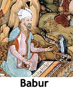 Babur, a descendant of Timur and Genghis Khan, swept through the region
in 1526, establishing the Mughal Empire - one of the richest single
dynasties ever to have existed.
Babur, a descendant of Timur and Genghis Khan, swept through the region
in 1526, establishing the Mughal Empire - one of the richest single
dynasties ever to have existed. In the aftermath of the rebellion a power shift within the
  A push for independence grew steadily in the early 1900s, along with
tensions between the Hindus and Muslims. As a minority, the Muslims were
cautious, due to the prospect of an almost exclusive Hindu-based
government, and tensions between the two flared.
A push for independence grew steadily in the early 1900s, along with
tensions between the Hindus and Muslims. As a minority, the Muslims were
cautious, due to the prospect of an almost exclusive Hindu-based
government, and tensions between the two flared.  In addition to the riots, one of the largest mass migrations ever
recorded in modern history occurred, with over 12 million Hindus, Sikhs
and Muslims migrating through the newly created nations of India and
In addition to the riots, one of the largest mass migrations ever
recorded in modern history occurred, with over 12 million Hindus, Sikhs
and Muslims migrating through the newly created nations of India and  Home to some of the most significant natural and man-made wonders on
the planet, and thus, a powerful exotic tourism magnet, the modern
open-door policies of India have put the tourist industry here on the
fast-track, as luxury hotels and beach resorts are constantly under
construction.
Home to some of the most significant natural and man-made wonders on
the planet, and thus, a powerful exotic tourism magnet, the modern
open-door policies of India have put the tourist industry here on the
fast-track, as luxury hotels and beach resorts are constantly under
construction. 

